St Ewe
St Ewe
| |
|---|---|
.jpg) All Saints' Church | |
 St Ewe St Ewe shown within Cornwall | |
| Population | 568 (2011 census) |
| OS grid reference | SW978461 |
| Civil parish |
|
| Unitary authority | |
| Ceremonial county | |
| Region | |
| Country | England |
| Sovereign state | United Kingdom |
| Post town | ST AUSTELL |
| Postcode district | PL26 |
| Dialling code | 01726 |
| Police | Devon and Cornwall |
| Fire | Cornwall |
| Ambulance | South Western |
| EU Parliament | South West England |
| UK Parliament | |
St Ewe (Cornish: Lannewa) is a civil parish and village in mid-Cornwall, England, United Kingdom. The village is situated approximately five miles (8 km) southwest of St Austell.[1]
Antiquities
Evidence of early medieval habitation is in the form of a roadside Celtic cross that once stood near Nunnery Hill (Charles Henderson in 1925 refers to it being at Lanhadron). However, the crosshead and shaft were thrown down in 1873 by a farmer looking for buried treasure, and both pieces were afterwards lost. The base has survived in situ with an inscription in insular script, unreadable except for the word crucem; Elisabeth Okasha dates the construction of this monument between the ninth and eleventh centuries.[2]
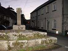
There is another cross at Corran, about half a mile east of the churchtown.[3] This cross is also known as Beacon Cross since its site is known as the Beacon. There is a cross at Heligan known as Bokiddick Cross; it came from Bokiddick Farm in the parish of Lanivet which was then owned by the Tremaynes who also owned Heligan. The cross in the churchtown stands on a massive base which is the only original part of it. The stones forming the cross came from elsewhere and nothing is known about the design of the original cross.[4]
Churches
The parish church is dedicated to St Ewe, a female saint of whom very little is known.[5] The church was originally a Norman cruciform building: the tower and spire were added in the 14th century and the south aisle in the 15th. There is a Norman font and a fine 15th-century rood screen.[6] The small manor of Lanewa was for a long time linked to the advowson of the church; it was probably the secular successor to a Celtic monastery.[7]
At Tucoyse was a Wesleyan Methodist chapel, and there were formerly Bible Christian chapels at Polmassick, Paramore, Kestle and Lower Sticker.[8]
Heligan
The Heligan estate is located at the eastern edge of the parish of St Ewe, overlooking the small port of Mevagissey. The long-term home of the Tremayne family, the estate is now best known as the location of the Lost Gardens of Heligan, a recently restored Victorian garden.[9]
Language
St Ewe was surveyed for the Survey of English Dialects.
Notes
- ↑ Ordnance Survey: Landranger map sheet 204 Truro & Falmouth ISBN 978-0-319-23149-4
- ↑ See the discussion and bibliography in Elisabeth Okasha, Corpus of early Christian inscribed stones of South-west Britain (Leicester: University Press, 1993), pp. 129-132
- ↑ Langdon, A. G. (1896) Old Cornish Crosses. Truro: Joseph Pollard; pp. 80-81
- ↑ Langdon, A. G. (2002) Stone Crosses in Mid Cornwall; 2nd ed. Federation of Old Cornwall Societies; pp. 35-36
- ↑ Doble, G. H. (1970) The Saints of Cornwall: part 5. Truro: Dean and Chapter; pp. 30-32
- ↑ Cornish Church Guide (1925) Truro: Blackford; p. 94
- ↑ Cornish Church Guide (1925) Truro: Blackford; p. 94
- ↑ "St Ewe; church history". GenUKI. Retrieved 1 December 2012.
- ↑ Smit, Tim (1999). The Lost Gardens of Heligan. Victor Gollancz. ISBN 0-575-06765-9.
External links
The St Ewe Parish Website: http://st-ewe-parish.co.uk
| Wikimedia Commons has media related to St Ewe. |
Cornwall Portal | |
| Unitary authorities | |
| Major settlements |
|
| Rivers | |
| Topics | |
Civil parishes of St Austell and Newquay constituency | ||
|---|---|---|
Cornwall Portal | ||