St. Lupicin, Manitoba
| St. Lupicin | |
|---|---|
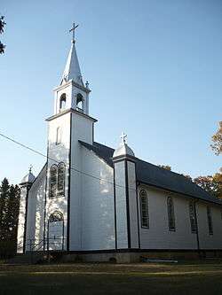 St. Lupicin Roman Catholic Church | |
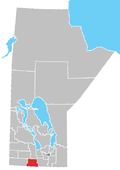
 St. Lupicin Location of St. Lupicin in Manitoba | |
| Coordinates: 49°27′31″N 98°28′35″W / 49.45861°N 98.47639°WCoordinates: 49°27′31″N 98°28′35″W / 49.45861°N 98.47639°W | |
| Country |
|
| Province |
|
| Region | Pembina Valley |
| Census Division | No. 4 |
| Government | |
| • Governing Body | Rural Municipality of Lorne Council |
| • MP | Candice Bergen |
| • MLA | Blaine Pedersen |
| Time zone | UTC−6 (CST) |
| • Summer (DST) | UTC−5 (CDT) |
| Area code(s) | 204, 431 |
| NTS Map | 062G08 |
| GNBC Code | GAXYQ |
St. Lupicin is a locality within the Rural Municipality of Lorne in south central Manitoba, Canada. It is located approximately 35 kilometers (22 miles) southwest of Carman, Manitoba.[1]
References
- ↑ "Geographical Names of Canada - Querying Distances". nrcan.gc.ca. 2011-10-24. Retrieved 2012-09-30.
| Towns |
|  | ||
|---|---|---|---|---|
| Villages |
| |||
| Rural municipalities |
| |||
| First Nations | ||||
| Indian reserves | ||||
| Unincorporated communities | ||||
This article is issued from
Wikipedia.
The text is licensed under Creative Commons - Attribution - Sharealike.
Additional terms may apply for the media files.