Sprague, Manitoba

Sprague
Location of Sprague in Manitoba
Sprague is a community in the Canadian province of Manitoba minutes from Minnesota and Ontario. It is located in the Rural Municipality of Piney, about one hour southeast of Steinbach and 1.5 hours southeast of Winnipeg. It is a small town located at the junctions of Manitoba Highway 12 and Provincial Road 308. The nearest major centres include Warroad, Fort Frances, Steinbach, and Thief River Falls.
Climate
| Climate data for Sprague | |||||||||||||
|---|---|---|---|---|---|---|---|---|---|---|---|---|---|
| Month | Jan | Feb | Mar | Apr | May | Jun | Jul | Aug | Sep | Oct | Nov | Dec | Year |
| Record high °C (°F) | 11.1 (52) |
12.8 (55) |
23.9 (75) |
33.3 (91.9) |
35.0 (95) |
36.7 (98.1) |
38.9 (102) |
36.0 (96.8) |
35.0 (95) |
30.0 (86) |
22.2 (72) |
9.4 (48.9) |
38.9 (102) |
| Average high °C (°F) | −10.4 (13.3) |
−6.3 (20.7) |
0.6 (33.1) |
10.3 (50.5) |
18.7 (65.7) |
23.0 (73.4) |
25.1 (77.2) |
24.8 (76.6) |
18.2 (64.8) |
10.5 (50.9) |
−1.1 (30) |
−8.5 (16.7) |
8.7 (47.7) |
| Daily mean °C (°F) | −16.3 (2.7) |
−12.3 (9.9) |
−5.1 (22.8) |
3.7 (38.7) |
11.4 (52.5) |
16.4 (61.5) |
18.7 (65.7) |
17.9 (64.2) |
11.9 (53.4) |
5.0 (41) |
−5.4 (22.3) |
−13.5 (7.7) |
2.7 (36.9) |
| Average low °C (°F) | −22.1 (−7.8) |
−18.2 (−0.8) |
−10.8 (12.6) |
−2.9 (26.8) |
4.1 (39.4) |
9.8 (49.6) |
12.2 (54) |
10.9 (51.6) |
5.6 (42.1) |
−0.6 (30.9) |
−9.8 (14.4) |
−18.5 (−1.3) |
−3.4 (26) |
| Record low °C (°F) | −48.3 (−54.9) |
−47.2 (−53) |
−45.6 (−50.1) |
−30 (−22) |
−13.3 (8.1) |
−6.7 (19.9) |
−1.7 (28.9) |
−5.6 (21.9) |
−11.1 (12) |
−27.2 (−17) |
−40 (−40) |
−46.7 (−52.1) |
−48.3 (−54.9) |
| Average precipitation mm (inches) | 26.6 (1.047) |
21.3 (0.839) |
23.5 (0.925) |
31.3 (1.232) |
69.1 (2.72) |
109.4 (4.307) |
104.5 (4.114) |
73.0 (2.874) |
70.7 (2.783) |
45.0 (1.772) |
37.1 (1.461) |
26.1 (1.028) |
637.6 (25.102) |
| Source: Environment Canada[1] | |||||||||||||
References
- ↑ "Canadian Climate Normals 1981–2010". Environment Canada. Retrieved 14 January 2018.
External links
Division No. 1, Manitoba (Eastern Manitoba) | ||
|---|---|---|
| Towns | 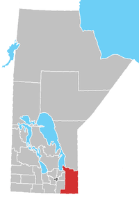 | |
| Local government districts | ||
| Rural municipalities | ||
| First Nations | ||
| Indian reserves |
| |
| Unorganized areas | ||
| Unincorporated communities | ||
Coordinates: 49°02′07″N 95°38′21″W / 49.03528°N 95.63917°W
This article is issued from
Wikipedia.
The text is licensed under Creative Commons - Attribution - Sharealike.
Additional terms may apply for the media files.