Splatt, Cornwall
Coordinates: 50°33′04″N 4°54′00″W / 50.551°N 4.900°W
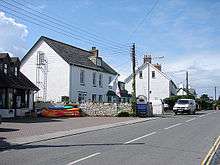
Rock Road, Splatt
Splatt is a small settlement in north Cornwall, England, United Kingdom at grid reference SW 945 763. It is situated between Pityme and Rock although the buildings along the Rock Road are continuous.[1]
It should not be confused with Splatt in the parish of Tresmeer.[2]
References
External links
![]()
Cornwall Portal | |
| Unitary authorities | |
| Major settlements |
|
| Rivers | |
| Topics | |
This article is issued from
Wikipedia.
The text is licensed under Creative Commons - Attribution - Sharealike.
Additional terms may apply for the media files.