Sōya Main Line
| Sōya Main Line | |||
|---|---|---|---|
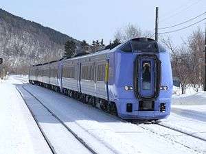 Super Sōya limited express train | |||
| Overview | |||
| Type | Heavy rail | ||
| Locale | Hokkaido | ||
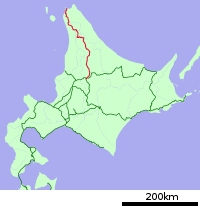
| Termini |
Asahikawa Wakkanai | ||
| Stations | 54 | ||
| Operation | |||
| Opened | 1898 | ||
| Owner | JR Hokkaido | ||
| Technical | |||
| Line length | 259.4 km (161.2 mi) | ||
| Track gauge | 1,067 mm (3 ft 6 in) | ||
| Electrification | Not electrified | ||
| |||
| Soya Main Line | |||||||||||||||||||||||||||||||||||||||||||||||||||||||||||||||||||||||||||||||||||||||||||||||||||||||||||||||||||||||||||||||||||||||||||||||||||||||||||||||||||||||||||||||||||||||||||||||||||||||||||||||||||||||||||||||||||||||||||||||||||||||||||||||||||||||||||||||||||||||||||||||||||||||||||||||||||||||||||||||||||||||||||||||||||||||||||||||||||||||||||||||||||||||||||||||||||||||||||||||||||||||||||||||||||||||||||||||||||||||||||||||||||||||||||||||||||||||||||||||||||||||||||||||
|---|---|---|---|---|---|---|---|---|---|---|---|---|---|---|---|---|---|---|---|---|---|---|---|---|---|---|---|---|---|---|---|---|---|---|---|---|---|---|---|---|---|---|---|---|---|---|---|---|---|---|---|---|---|---|---|---|---|---|---|---|---|---|---|---|---|---|---|---|---|---|---|---|---|---|---|---|---|---|---|---|---|---|---|---|---|---|---|---|---|---|---|---|---|---|---|---|---|---|---|---|---|---|---|---|---|---|---|---|---|---|---|---|---|---|---|---|---|---|---|---|---|---|---|---|---|---|---|---|---|---|---|---|---|---|---|---|---|---|---|---|---|---|---|---|---|---|---|---|---|---|---|---|---|---|---|---|---|---|---|---|---|---|---|---|---|---|---|---|---|---|---|---|---|---|---|---|---|---|---|---|---|---|---|---|---|---|---|---|---|---|---|---|---|---|---|---|---|---|---|---|---|---|---|---|---|---|---|---|---|---|---|---|---|---|---|---|---|---|---|---|---|---|---|---|---|---|---|---|---|---|---|---|---|---|---|---|---|---|---|---|---|---|---|---|---|---|---|---|---|---|---|---|---|---|---|---|---|---|---|---|---|---|---|---|---|---|---|---|---|---|---|---|---|---|---|---|---|---|---|---|---|---|---|---|---|---|---|---|---|---|---|---|---|---|---|---|---|---|---|---|---|---|---|---|---|---|---|---|---|---|---|---|---|---|---|---|---|---|---|---|---|---|---|---|---|---|---|---|---|---|---|---|---|---|---|---|---|---|---|---|---|---|---|---|---|---|---|---|---|---|---|---|---|---|---|---|---|---|---|---|---|---|---|---|---|---|---|---|---|---|---|---|---|---|---|---|---|---|---|---|---|---|---|---|---|---|---|---|---|---|---|---|---|---|---|---|---|---|---|---|---|---|---|---|---|---|---|---|---|---|---|---|---|---|---|---|---|---|---|---|---|---|---|---|---|---|---|---|---|---|---|---|---|---|---|---|---|---|---|---|---|---|---|---|---|---|---|---|---|---|---|---|---|---|---|---|---|---|---|---|---|---|---|---|---|---|---|---|---|---|---|---|---|---|---|---|---|---|---|---|---|---|---|---|---|---|---|---|---|---|---|---|---|---|---|
| |||||||||||||||||||||||||||||||||||||||||||||||||||||||||||||||||||||||||||||||||||||||||||||||||||||||||||||||||||||||||||||||||||||||||||||||||||||||||||||||||||||||||||||||||||||||||||||||||||||||||||||||||||||||||||||||||||||||||||||||||||||||||||||||||||||||||||||||||||||||||||||||||||||||||||||||||||||||||||||||||||||||||||||||||||||||||||||||||||||||||||||||||||||||||||||||||||||||||||||||||||||||||||||||||||||||||||||||||||||||||||||||||||||||||||||||||||||||||||||||||||||||||||||||
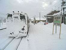
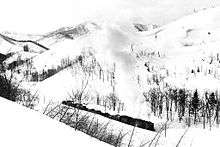
The Sōya Main Line (宗谷本線 Sōya-honsen) is a Japanese railway line operated by Hokkaido Railway Company (JR Hokkaido) in Hokkaido. The line connects Asahikawa Station in Asahikawa and Wakkanai Station in Wakkanai, and is the northernmost railway line in Japan. The name comes from Sōya Subprefecture.
On 19 November 2016, JR Hokkaido's President announced plans to rationalise the network by up to 1,237 km, or ~50% of the current network,[1] including proposed conversion of the Nayoro - Wakkanai section of the Soya Line to Third Sector operation, but if local governments are not agreeable, the section will face closure.
Services
Two Super Sōya limited express services each way operate between Sapporo and Wakkanai daily, and one Sarobetsu service each way also operates between Sapporo and Wakkanai daily. The latter service does not include Green car (first class) accommodation.[2]
All-stations "Local" train services operate between Asahikawa and Nayoro, at approximately 1 to 2 hour intervals. All-stations "Local" train services operate between Nayoro and Wakkanai, at approximately 3 to 4 hour intervals. Four Nayoro Rapid services operate in each direction daily.
Stations
- L: Limited Express (Super Sōya/Sarobetsu)
- R: All Rapids
- r: Some Rapids
History
The line was originally built as part of a link between mainland Japan and the then Japanese northern frontier of Karafuto (southern half of Sakhalin Island). From Wakkanai Port, a ferry to then Ōdomari (present Korsakov) operated until the end of World War II.
The first segment of the line from Asahigawa (present Asahikawa) to Nagayama was built by the Hokkaido Government Railway in 1898. The line was extended to Nayoro in 1903, and to Wakkanai in 1922 along the route of the later Tempoku Line (天北線, Tenpoku-sen) via Hamatombetsu. The present route via Horonobe was opened as part of the Teshio Line (天塩線, Teshio-sen).
After Japan's defeat in the war, the line lost its function as a link to Sakhalin, but remained important as a trunk line into the northern part of Hokkaido. The Sōya Main Line gradually lost all of its branch lines, and presently constitutes a long branch from the Hakodate Main Line.
Timeline
- August 12, 1898: Opened as Teshio Line (天塩線 Teshio-sen) (I) of Hokkaido Government Railway, between Asahigawa (present Asahikawa) and Nagayama
- November 25, 1898: Extended to Ranru
- November 15, 1899: Extended to Wassamu
- August 5, 1900: Extended to Shibetsu
- September 3, 1900: Extended to Nayoro
- April 1, 1905: Transferred to Imperial Japanese Government Railways
- November 3, 1911: Extended to Onnenai
- September 21, 1912: Renamed Sōya Line (宗谷線 Sōya-sen)
- November 5, 1912: Extended to Otoineppu
- October 20, 1919: Renamed Sōya Main Line (宗谷本線 Sōya Honsen)
- October 5, 1921: Renamed Sōya Line
- November 1, 1922: Completed to Wakkanai (present Minami-Wakkanai) via later Tempoku Line
- November 4, 1922: Renamed back to Sōya Main Line
- November 8, 1922: Teshio Line (II) between Otoineppu and Pompira (present Teshio-Nakagawa)
- May 1, 1923: Chihaku Ferry (稚泊連絡船 Chihaku Renrakusen) commenced Wakkanai - Ōdomari
- November 10, 1923: Extended to Toikambetsu
- June 25, 1924: Teshio North Line (天塩北線 Teshio-hokusen) opened Wakkanai - Kabutonuma. Teshio Line renamed Teshio South Line (天塩南線 Teshio-nansen)
- July 20, 1925: Teshio South Line extended to Horonobe
- September 25, 1926: Teshio South and North lines connected, renamed to Teshio Line (天塩線 Teshio-sen) (II), Otoineppu - Wakkanai
- December 26, 1928: Extended to Wakkanaikō (present Wakkanai).
- April 1, 1930: Entire stretch of the Teshio Line became a part of Sōya Main Line. The section Otoineppu - Hamatombetsu - Wakkanai separated as Kitami Line (北見線 Kitami-sen), later Tempoku Line (天北線 Tempoku-sen).
- June 30, 1935: Teshio Line (III), later Haboro Line (羽幌線 Haboro-sen) from Horonobe opened.
- August 25, 1945: Chihaku Ferry ceased operation when all of Sakhalin becomes part of the Soviet Union.
- July 15, 1965: The 1256m Shimodaira Tunnel and realignment opened to avoid an avalanche trouble-spot.
- November 10, 1984: Automated block system introduced, ticketing of most (29) stations unstaffed
- November 1, 1986: CTC implemented, above noted stations completely unstaffed.
- April 1, 1987: Japanese National Railways privatized, Hokkaido Railway Company succeeded the entire line as Category 1, Japan Freight Railway Company as Category 2 between Asahikawa and Nayoro. All the temporary stations were reclassified as regular stations
- 1995: The ferry between Wakkanai and Korsakov "resumed" after 50 years, although not directly connected to the railway.
- March 2000: Tracks of Asahikawa - Nayoro upgraded for faster operation. The Super Sōya limited express train commenced.
Former connecting lines
- Shibetsu station - A 762mm (2'6") gauge line was constructed between 1920-25 along the Teshio River valley to transport forestry products, extending 21.4 km to 'Upper' Shibetsu, where it connected to the Shibetsu Forest Railway. Initially horse drawn, a steam locomotive was introduced in 1928. The line closed in 1959.
- Nayoro station;
- A 138 km line known as the Nayoro Main Line was built from Nayoro to Engaru on the Sekihoku Main Line between 1915-1921, operating until 1989. There were four lines connecting to the Nayoro Main line:
- the 20 km Kohin'nan line from Okoppe to Om, operated from 1935-85. Some construction work on a proposed extension to Kitami Esashi (see below) was undertaken before the proposal was abandoned.
- the 34 km line from Shokotsu to Kitami Takinoue, opened 1923 and closed 1985.
- the 28 km 762mm gauge line from Monbetsu to Motoyama, which operated from 1943–73
- the 6 km 762mm gauge line from Yubetsu to Saromako, which operated from 1930–39
- Nayoro was also the junction for the Shinmei line to Fukagawa on the Hakodate Main Line, which reached the Soya line in 1941, closing in 1995. A 51.2 km line was proposed from Shumarinai on that line to Chikubetsu on the Hoboro line (see below) with construction commencing in 1959. A substantial steel truss bridge was constructed before work was abandoned in 1962.
- Bifuka station - A 21 km 762mm gauge line was built to Niupu in 1935. In 1960 it was decided to replace the line with a 1067mm gauge line and extend it 58 km to Kitami Esashi, the terminus of a line from Hamatonbetsu on the Tempoku line (see below). The 762mm gauge line closed in 1963 and the 1067mm line opened in 1964. Substantial construction of the line to Kitami Esashi continued until abandoned in 1979, after 13.3 Billion Yen had been expended. The Bifuka - Niupu section closed in 1985.
- Otoineppu station - The Tempoku line was constructed north commencing in 1914, reaching Minami-Wakkanai in 1922. It closed in 1989. This line had the Hamatonbetsu - Kitami Esashi branch line operating from 1936 until 1985. The Utanobori Municipal Tramway was a network of 762mm gauge lines, with a 16.2 km line from Shotonbetsu to Kitami Esashi and 2 branch lines, each 10 km long. It operated 1929-70, being horse drawn until 1933.
- Toyotomi station - The Nisso Coal Co. operated an 18 km line to Sanko from 1940/45 until the mine closed in 1972.
- Toikanbetsu station - The Horonobe Municipal Tramway was a 16 km 762mm gauge line to Kamitoikan, which operated 1930-71. It was extended 4 km to a coal mine in 1941, at which time a steam locomotive was introduced. The coal mine and extension closed in 1958.
- Horonobe station - The initial northern section of the Hoboro line opened in 1935. The initial southern section from Rumoi opened in 1927, and the sections were linked in 1958. The line closed in 1987.
See also
References
| Wikimedia Commons has media related to Sōya Main Line. |
- ↑ http://www.japantimes.co.jp/news/2016/11/19/business/jr-hokkaido-says-cant-maintain-half-railways/#.WDjkB9J96Ul
- ↑ JR Timetable, April 2011 issue
Mass transit in Hokkaido | |
|---|---|
| JR named trains | |
| Other railways | |
| Terminals |
|
| Public Ferries |
|
| Miscellaneous |
|
| |