Southville, Kentucky
| Southville, Kentucky | |
|---|---|
| Unincorporated community | |
 Southville, Kentucky | |
| Coordinates: 38°06′36″N 85°10′55″W / 38.11000°N 85.18194°WCoordinates: 38°06′36″N 85°10′55″W / 38.11000°N 85.18194°W | |
| Country | United States |
| State | Kentucky |
| County | Shelby |
| Elevation | 820 ft (250 m) |
| Time zone | UTC-5 (Eastern (EST)) |
| • Summer (DST) | UTC-4 (EDT) |
| Area code(s) | 502 |
| GNIS feature ID | 504010[1] |
Southville, Kentucky is an unincorporated community in Shelby County, Kentucky.[1] It is the location of, or nearest community to, several places listed on the National Register of Historic Places:[2][3]
- Carriss's Feed Store, built in 1915, at KY 55 and KY 44, Southville, (Adams,James W.), NRHP-listed[3]
- Carriss's Store, KY 714 and KY 53, Southville, (Adams,James W.), NRHP-listed[3]
- Dr. William Morris Office and House, KY 53, Southville, (Adams,James W.), NRHP-listed[3]
References
- 1 2 "Southville". Geographic Names Information System. United States Geological Survey.
- ↑ Shelby County MRA
- 1 2 3 4 National Park Service (2010-07-09). "National Register Information System". National Register of Historic Places. National Park Service.
Municipalities and communities of Shelby County, Kentucky, United States | ||
|---|---|---|
| Cities | 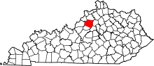 | |
| Unincorporated communities | ||
| Footnotes | ‡This populated place also has portions in an adjacent county or counties | |
This article is issued from
Wikipedia.
The text is licensed under Creative Commons - Attribution - Sharealike.
Additional terms may apply for the media files.