Southern Indian Lake
| Southern Indian Lake | |
|---|---|
 | |
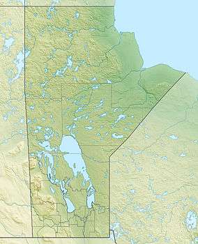 Southern Indian Lake Location in Manitoba | |
| Location | Division No. 23, Manitoba, Canada |
| Coordinates | 57°10′N 98°30′W / 57.167°N 98.500°WCoordinates: 57°10′N 98°30′W / 57.167°N 98.500°W |
| Primary inflows | Churchill River |
| Primary outflows | Churchill River and Rat River |
| Catchment area | 242,000 km2 (93,000 sq mi) |
| Basin countries | Canada |
| Surface area | 2,247 km2 (868 sq mi) |
| Average depth | 9.8 m (32 ft) |
| Max. depth | 30 m (98 ft) |
| Water volume | 23.4 km3 (19,000,000 acre⋅ft) |
| Shore length1 | 3,798 km (2,360 mi) |
| Surface elevation | 258 m (846 ft) |
| Frozen | between October–June |
| Islands | many |
| Settlements | South Indian Lake |
| References | [1][2][3][4] |
| 1 Shore length is not a well-defined measure. | |
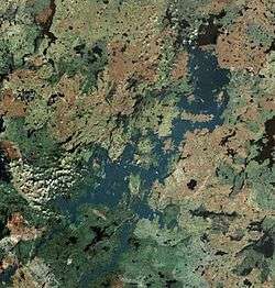
Southern Indian Lake is a large lake in Manitoba, Canada. It has an area of 2,247 km2 (868 sq mi) (including islands) with a surface elevation of 258 m (846 ft).
Southern Indian Lake is the fourth largest lake in Manitoba. It has a complex shoreline with many islands, long peninsulas and deep bays.[5] The Churchill River flows through the lake.
The community of South Indian Lake is located on the southeast shore, about 130 km (81 mi) (by air) north of the city of Thompson. It had a population of 767 in 2011 and is the main settlement of the O-Pipon-Na-Piwin Cree Nation, a First Nations band government.[6]
The lake and the settlement are accessed by the South Indian Lake Airport and Manitoba Provincial Road 493 (Pr493). Pr493. a gravel road, begins at Leaf Rapids on the Pr391 (also a gravel road) and runs 219.1 km (136.1 mi) northeast to its terminus at South Indian Lake. The nearest city, Thompson, is 436 km (271 mi) by road.
Churchill River Diversion
The Churchill River Diversion of the Nelson River Hydroelectric Project diverts part of the Churchill River at Missi Falls, the natural outflow of Southern Indian Lake, south into the Rat River branch of the Burntwood River. The control dam at Missi Falls (Missi Falls Control Structure) raised the lake level 3 metres.[7] An artificial outflow channel (South Bay Diversion Channel) was also created from South Bay of Southern Indian Lake to Issett Lake.[8] The dam at Notigi (Notigi Control Structure) on the Rat River controls the flow to the Nelson River system.[9][10]
See also
References
- ↑ "Principal lakes, elevation and area, by province and territory". Statistics Canada. 2005-02-02. Retrieved 2015-03-11.
- ↑ "World Lake Database (Lakes in Canada)". Archived from the original on 2016-03-06. Retrieved 2015-02-21.
- ↑ "Natural Resources Canada-Canadian Geographical Names (Southern Indian Lake)". Retrieved 2015-03-30.
- ↑ "Atlas of Canada Toporama". Retrieved 2015-03-30.
- ↑ International Lake Environment Committee Archived 2012-03-04 at the Wayback Machine.
- ↑ "Population and dwelling counts, for Canada and census subdivisions (municipalities), 2011 and 2006 censuses". Statistics Canada, 2011 Census. Retrieved 2015-04-01.
- ↑ "Natural Resources Canada-Canadian Geographical Names (Missi Falls Control Structure)". Retrieved 2015-03-30.
- ↑ "Natural Resources Canada-Canadian Geographical Names (South Bay Diversion Channel)". Retrieved 2015-03-30.
- ↑ "Natural Resources Canada-Canadian Geographical Names (Notigi Control Structure)". Retrieved 2015-03-30.
- ↑ "Manitoba Hydro (Churchill River Diversion)". Retrieved 2015-03-30.
External links
- The Canadian Encyclopedia (Southern Indian Lake)
- The Manitoba Historical Society (Native People and Hydroelectric Development in Northern Manitoba, 1957-1987: The Promise and the Reality)
- Mennonite Central Committee (Churchill River Diversion)
| Provinces |
|
|---|---|
| Territories | |
| |