South Londonderry Township, Lebanon County, Pennsylvania
| South Londonderry Township, Pennsylvania | |
|---|---|
| Township | |
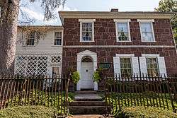 Colebrook Iron Master's House, built in the 1790s | |
 Map of Lebanon County, Pennsylvania highlighting South Londonderry Township | |
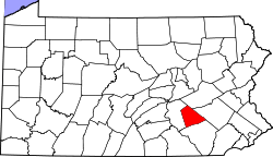 Map of Lebanon County, Pennsylvania | |
| Country | United States |
| State | Pennsylvania |
| County | Lebanon |
| Incorporated | 1894 |
| Area[1] | |
| • Total | 24.38 sq mi (63.13 km2) |
| • Land | 24.35 sq mi (63.07 km2) |
| • Water | 0.03 sq mi (0.06 km2) |
| Population (2010) | |
| • Total | 6,991 |
| • Estimate (2016)[2] | 7,942 |
| • Density | 326.15/sq mi (125.93/km2) |
| Time zone | UTC-5 (Eastern (EST)) |
| • Summer (DST) | UTC-4 (EDT) |
| Area code(s) | 717 |
| FIPS code | 42-075-72296 |
| Historical population | |||
|---|---|---|---|
| Census | Pop. | %± | |
| 2000 | 5,458 | — | |
| 2010 | 6,991 | 28.1% | |
| Est. 2016 | 7,942 | [2] | 13.6% |
| U.S. Decennial Census[3] | |||
South Londonderry Township is a township in Lebanon County, Pennsylvania, United States. It is part of the Lebanon, PA Metropolitan Statistical Area. The population was 6,991 at the 2010 census.[4]
History
Londonderry Township was divided into North Londonderry Township and South Londonderry Township in 1894.
The Colebrook Iron Master's House and Dr. B. Stauffer House are listed on the National Register of Historic Places.[5][6]
Geography
According to the United States Census Bureau, the township has a total area of 24.1 square miles (62.4 km²), of which, 24.1 square miles (62.3 km²) of it is land and 0.04% is water.
Demographics
As of the census[7] of 2000, there were 5,458 people, 2,062 households, and 1,585 families residing in the township. The population density was 226.8 people per square mile (87.6/km²). There were 2,138 housing units at an average density of 88.9/sq mi (34.3/km²). The racial makeup of the township was 97.86% White, 0.53% African American, 0.04% Native American, 0.71% Asian, 0.20% from other races, and 0.66% from two or more races. Hispanic or Latino of any race were 0.59% of the population.
There were 2,062 households, out of which 34.7% had children under the age of 18 living with them, 67.4% were married couples living together, 6.6% had a female householder with no husband present, and 23.1% were non-families. 19.8% of all households were made up of individuals, and 7.4% had someone living alone who was 65 years of age or older. The average household size was 2.61 and the average family size was 3.02.
In the township the population was spread out, with 25.3% under the age of 18, 5.9% from 18 to 24, 30.7% from 25 to 44, 26.0% from 45 to 64, and 12.1% who were 65 years of age or older. The median age was 39 years. For every 100 females there were 95.3 males. For every 100 females age 18 and over, there were 91.9 males.
The median income for a household in the township was $51,699, and the median income for a family was $63,112. Males had a median income of $43,810 versus $29,116 for females. The per capita income for the township was $24,296. About 0.8% of families and 1.5% of the population were below the poverty line, including 2.8% of those under age 18 and none of those age 65 or over.
References
- ↑ "2016 U.S. Gazetteer Files". United States Census Bureau. Retrieved Aug 14, 2017.
- 1 2 "Population and Housing Unit Estimates". Retrieved June 9, 2017.
- ↑ "Census of Population and Housing". Census.gov. Retrieved June 4, 2016.
- ↑ https://factfinder.census.gov/faces/nav/jsf/pages/community_facts.xhtml#
- ↑ National Park Service (2010-07-09). "National Register Information System". National Register of Historic Places. National Park Service.
- ↑ "National Register of Historic Places Listings". Weekly List of Actions Taken on Properties: 6/28/10 through 7/02/10. National Park Service. 2010-07-09.
- ↑ "American FactFinder". United States Census Bureau. Retrieved 2008-01-31.
External links
Municipalities and communities of Lebanon County, Pennsylvania, United States | ||
|---|---|---|
| City | | |
| Boroughs | ||
| Townships | ||
| CDPs | ||
| Unincorporated communities | ||
Coordinates: 40°16′00″N 76°31′59″W / 40.26667°N 76.53306°W