Lawn, Pennsylvania
| Lawn, Pennsylvania | ||
|---|---|---|
| Unincorporated community | ||
| ||
 Lawn | ||
| Coordinates: 40°13′12″N 76°32′21″W / 40.22000°N 76.53917°WCoordinates: 40°13′12″N 76°32′21″W / 40.22000°N 76.53917°W | ||
| Country | United States | |
| State | Pennsylvania | |
| County | Lebanon | |
| Township | South Londonderry | |
| Elevation | 479 ft (146 m) | |
| Time zone | UTC-5 (Eastern (EST)) | |
| • Summer (DST) | UTC-4 (EDT) | |
| ZIP code | 17041 | |
| Area code(s) | 717 | |
| GNIS feature ID | 1179046[1] | |

Lawn is an unincorporated community in South Londonderry Township in Lebanon County, Pennsylvania, United States. Lawn is located at the intersection of Pennsylvania Route 241 and Lawn Road.[2]
References
- ↑ "Lawn". Geographic Names Information System. United States Geological Survey.
- ↑ Lebanon County, Pennsylvania Highway Map (PDF) (Map). PennDOT. 2012. Retrieved September 3, 2013.
Municipalities and communities of Lebanon County, Pennsylvania, United States | ||
|---|---|---|
| City | 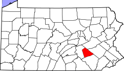 | |
| Boroughs | ||
| Townships | ||
| CDPs | ||
| Unincorporated communities | ||
This article is issued from
Wikipedia.
The text is licensed under Creative Commons - Attribution - Sharealike.
Additional terms may apply for the media files.