South La Paloma, Texas
| South La Paloma, Texas | |
|---|---|
| Unincorporated community | |
 South La Paloma, Texas  South La Paloma, Texas | |
| Coordinates: 27°53′41″N 97°58′07″W / 27.89472°N 97.96861°WCoordinates: 27°53′41″N 97°58′07″W / 27.89472°N 97.96861°W | |
| Country | United States |
| State | Texas |
| County | Jim Wells |
| Area[1] | |
| • Total | 1.452 sq mi (3.76 km2) |
| • Land | 1.452 sq mi (3.76 km2) |
| • Water | 0 sq mi (0 km2) |
| Elevation | 154 ft (47 m) |
| Population (2010)[1] | |
| • Total | 345 |
| • Density | 240/sq mi (92/km2) |
| Time zone | UTC-6 (Central (CST)) |
| • Summer (DST) | UTC-5 (CDT) |
| Area code(s) | 361 |
| GNIS feature ID | 2584740[2] |
South La Paloma is an unincorporated community and census-designated place in Jim Wells County, Texas, United States. Its population was 345 as of the 2010 census.[1] Prior to 2010, the community was grouped with nearby Alfred as part of the Alfred-South La Paloma census-designated place.
Geography
According to the U.S. Census Bureau, the community has an area of 1.452 square miles (3.76 km2), all of it land.[1]
References
Municipalities and communities of Jim Wells County, Texas, United States | ||
|---|---|---|
| Cities | 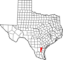 | |
| Village | ||
| CDPs | ||
| Other unincorporated communities | ||
| Footnotes | ‡This populated place also has portions in an adjacent county or counties | |
This article is issued from
Wikipedia.
The text is licensed under Creative Commons - Attribution - Sharealike.
Additional terms may apply for the media files.