Turkistan Region
| Turkistan Region Túrkistan oblysy | ||
|---|---|---|
| Region | ||
 | ||
| ||
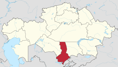 Map of Kazakhstan, location of Turkistan Region highlighted | ||
| Coordinates: 43°00′N 068°30′E / 43.000°N 68.500°ECoordinates: 43°00′N 068°30′E / 43.000°N 68.500°E | ||
| Country |
| |
| Capital | Turkistan | |
| Government | ||
| • Akim | Janseyit Tuimebayev | |
| Area[1] | ||
| • Total | 117,249 km2 (45,270 sq mi) | |
| Population (2013-02-01)[2] | ||
| • Total | 2,685,009 | |
| • Density | 23/km2 (59/sq mi) | |
| Time zone | UTC+6 (East) | |
| • Summer (DST) | UTC+6 (not observed) | |
| Postal codes | 160000 | |
| Area codes | +7 (725) | |
| ISO 3166 code | KZ-YUZ | |
| Vehicle registration | 13, X | |
| Districts | 11 | |
| Cities | 8 | |
| Townships | 13 | |
| Villages | 932 | |
| Website |
www | |
Turkistan Region (Kazakh: Түркістан облысы, translit. Túrkistan oblysy; Russian: Туркестанская область), previously South Kazakhstan Region (Kazakh: Оңтүстік Қазақстан облысы, translit. Ońtústik Qazaqstan oblysy; Russian: Южно-Казахстанская область, translit. Yuzhno-Kazakhstanskaya oblast), is the southernmost region of Kazakhstan. Population: 2,469,367 (2009 Census results);[3] 1,978,339 (1999 Census results).[3] Its capital is Turkistan. Other cities in South Kazakhstan include Sayram, Kentau, Arys, Shardara, Zhetisai, Saryagash, and Lenger. This region and Atyrau Region are Kazakhstan's two smallest regions; both are about 117,300 square kilometers in area. South Kazakhstan borders the neighboring country of Uzbekistan (and is very near the Uzbekistan capital Tashkent), as well as three other Kazakhstan regions: Karaganda Region (to the north), Kyzylorda Region (to the west), and Jambyl Region (to the east). The Syr Darya passes through the region, on its way to the Aral Sea. Also, an oil pipeline runs from Turkmenabat, Turkmenistan to Omsk, Russia (where it connects with a larger, Siberian pipeline) through South Kazakhstan. Oil, lead and zinc are refined in Shymkent.
The Region was created as South Kazakhstan Oblast in Kazakh SSR of Soviet Union. Between 1962 and 1992 it was named Chimkent Oblast and from 1992 until 19 June 2018 it was again named South Kazakhstan Oblast. The administrative center of the region was Shymkent.
On 19 June 2018 Shymkent was taken out of the region and subordinated directly to the government of Kazakhstan, the administrative center moved to Turkistan, and the region renamed Turkistan Region.[4]
Demographics
The South Kazakhstan Region is the most densely populated of Kazakhstan's many regions. This derives from the oblast's gentler climate, better irrigation infrastructure, and proximity to historical population centers (such as Uzbekistan's Tashkent and the Silk Road cities of Samarkand and Bukhara). It is also the fastest growing of Kazakhstan's regions, due to two main factors. One is the birthrate among traditional Kazakh and Uzbek families, where families of five to eight children are commonplace. The other is the exodus of cheap migrant labor from northern Uzbekistan. These migrant workers sometimes become full-fledged immigrants, and if they are ethnic Kazakhs this process is easily green-lighted through local governments for an (unacknowledged and under-the-table) fee.
As such, South Kazakhstan Region is the only region with a demographic breakdown where ethnic Russians are not in the first or second most populous categories. Census results are old and made using Soviet methods that served propaganda over accuracy, but they still point to Kazakhs being the most populous, closely followed by Uzbeks, with Russians bringing in a distant third.
The population of South Kazakhstan Region, despite the obvious numerical prevalence of Kazakhs (which has considerably amplified from the beginning 1990 and now the percentage of Kazakhs in the population is around 72%), differs a considerable ethnolanguage variety. So in the area population it is traditionally wide (about 18% of all population) the Uzbeks making a considerable part of the population of some cities and areas of area are presented (to Sauries, Turkestan, Aksukent, Ikan), live Russians (basically in the city of Shymkent though their share was considerably reduced for last 20 years from more than 23% in 1980 to under 6% now), Tajiks, Koreans, Kurds live also.
Languages
Main languages are Kazakh, Russian (including as means of international dialogue) and Uzbek.
History
Historically speaking, South Kazakhstan Region is home to Kazakhstan's oldest and greatest marvels. Two thousand years ago it was part of the northern border of the Persian Empire. It owes its long history of habitation to a mixing of Persian culture and science with the native Turkic/Mongol tribal clans. South Kazakhstan Region was part of the Satrap of Sogdiana.
Some places of historical interest include the cities of Turkestan, Otrar and Sayram. Sayram was the birthplace of Ahmed Yasavi (1103–66), a great Sufic scholar and author that lived and worked throughout Central Asia. He is entombed in a mausoleum complex that stands in present-day Turkestan, and which has been named a World Heritage Site by UNESCO. It was commissioned by Amir Temur (Tamerlane) to increase his standing among the area. The mausoleum was built by Persian masters, though it was left unfinished with the death of Tamerlane. The original scaffolding that would have been used to apply the colored-tile still protrudes from the front entrance.
Administrative divisions
As of 2013, the region was administratively divided into eleven districts and the cities of Shymkent, Arys, Kentau, and Turkestan.[5]
- Baydibek District, with the administrative center in the selo of Shayan;
- Kazygurt District, the selo of Kazygurt;
- Maktaaral District, the town of Zhetisay;
- Ordabasy District, the selo of Temirlan;
- Otyrar District, the selo of Shauldir;
- Saryagash District, the town of Saryagash;
- Sayram District, the selo of Aksukent;
- Shardara District, the town of Shardara;
- Sozak District, the selo of Sholakkorgan;
- Tole Bi District, the town of Lenger;
- Tulkibas District, the selo of Turar Ryskulov.
References
- ↑ Official site - General Information Archived 2011-07-22 at the Wayback Machine.
- ↑ Agency of statistics of the Republic of Kazakhstan: Численность населения Республики Казахстан по областям с началa 2013 года до 1 февраля 2013 года (russisch; Excel-Datei; 55 kB).
- 1 2 "Население Республики Казахстан" (in Russian). Департамент социальной и демографической статистики. Retrieved 8 December 2013.
- ↑ "Публичное подписание Указа «О некоторых вопросах административно-территориального устройства Республики Казахстан»" (in Russian). President of Kazakhstan. 19 June 2018. Retrieved 21 June 2018.
- ↑ "Akimats of the region's cities and districts". The official portal of akimat of South Kazakhstan Region. Archived from the original on 19 December 2012. Retrieved 20 March 2013.
- National Geographic Atlas of the World, Eighth Edition.
External links
![]()
Places adjacent to Turkistan Region | ||||||||||
|---|---|---|---|---|---|---|---|---|---|---|
| ||||||||||
Capital: Turkistan | ||
| Districts | 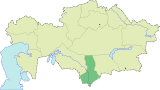 | |
| Major cities | ||
| Regions |  | |
|---|---|---|
| Special status cities | ||