South Hero, Vermont
| South Hero, Vermont | |
|---|---|
| Town | |
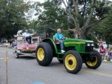
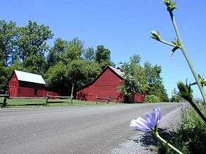 A barn in South Hero | |
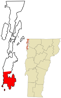 Location in Grand Isle County and the state of Vermont | |
 South Hero Location in Grand Isle County and the state of Vermont | |
| Coordinates: 44°38′50″N 73°18′36″W / 44.64722°N 73.31000°WCoordinates: 44°38′50″N 73°18′36″W / 44.64722°N 73.31000°W | |
| Country | United States |
| State | Vermont |
| County | Grand Isle |
| Communities |
South Hero Keeler Bay |
| Area | |
| • Total | 47.5 sq mi (123.0 km2) |
| • Land | 14.9 sq mi (38.6 km2) |
| • Water | 32.6 sq mi (84.4 km2) |
| Elevation | 95 ft (29 m) |
| Population (2010) | |
| • Total | 1,631 |
| • Density | 109/sq mi (42.2/km2) |
| Time zone | UTC-5 (Eastern (EST)) |
| • Summer (DST) | UTC-4 (EDT) |
| ZIP code | 05486 |
| Area code(s) | 802 |
| FIPS code | 50-67000[1] |
| GNIS feature ID | 1462213[2] |
| Website |
www |
South Hero is the most populous town that is both comprising part of Lake Champlain's largest island of Grand Isle and in Grand Isle County, Vermont. South Hero's population was 1,631 at the 2010 census.[3]
Geography
The town of South Hero includes the southern half of South Hero Island (also known as Grand Isle), as well as several smaller islands in Lake Champlain, including Providence Island and Stave Island to the southwest. To the west, across Lake Champlain, it is bordered by the towns of Plattsburgh and Peru in Clinton County, New York. To the east, across the eastern arm of Lake Champlain, is the town of Milton in Chittenden County, Vermont, and to the south across the lake is the town of Colchester, also in Chittenden County.
U.S. Route 2 crosses the town, leaving north into the town of Grand Isle and to the east, across Lake Champlain, into a corner of the town of Milton. Burlington, the largest city in Vermont, is 19 miles (31 km) to the south by road, and Rouses Point, New York, is 31 miles (50 km) to the north.
According to the United States Census Bureau, the town of South Hero has a total area of 47.5 square miles (123.0 km2), of which 14.9 square miles (38.6 km2) are land and 32.6 square miles (84.4 km2), or 68.59%, are water.[3]
Demographics
| Historical population | |||
|---|---|---|---|
| Census | Pop. | %± | |
| 1790 | 537 | — | |
| 1800 | 611 | 13.8% | |
| 1810 | 826 | 35.2% | |
| 1820 | 842 | 1.9% | |
| 1830 | 717 | −14.8% | |
| 1840 | 664 | −7.4% | |
| 1850 | 705 | 6.2% | |
| 1860 | 617 | −12.5% | |
| 1870 | 586 | −5.0% | |
| 1880 | 620 | 5.8% | |
| 1890 | 559 | −9.8% | |
| 1900 | 917 | 64.0% | |
| 1910 | 605 | −34.0% | |
| 1920 | 606 | 0.2% | |
| 1930 | 641 | 5.8% | |
| 1940 | 611 | −4.7% | |
| 1950 | 567 | −7.2% | |
| 1960 | 614 | 8.3% | |
| 1970 | 868 | 41.4% | |
| 1980 | 1,188 | 36.9% | |
| 1990 | 1,404 | 18.2% | |
| 2000 | 1,696 | 20.8% | |
| 2010 | 1,631 | −3.8% | |
| Est. 2014 | 1,627 | [4] | −0.2% |
| U.S. Decennial Census[5] | |||
As of the census[1] of 2000, there were 1,696 people, 663 households, and 472 families residing in the town. The population density was 112.3 people per square mile (43.4/km2). There were 1,036 housing units at an average density of 68.6 per square mile (26.5/km2). The racial makeup of the town was 97.94% White, 0.24% African American, 0.47% Native American, 0.29% Asian, 0.12% from other races, and 0.94% from two or more races. Hispanic or Latino of any race were 0.53% of the population.
There were 663 households out of which 32.6% had children under the age of 18 living with them, 61.7% were married couples living together, 6.0% had a female householder with no husband present, and 28.7% were non-families. 21.0% of all households were made up of individuals and 7.1% had someone living alone who was 65 years of age or older. The average household size was 2.56 and the average family size was 2.98.
In the town, the population was spread out with 24.9% under the age of 18, 5.5% from 18 to 24, 28.8% from 25 to 44, 29.5% from 45 to 64, and 11.1% who were 65 years of age or older. The median age was 40 years. For every 100 females, there were 98.1 males. For every 100 females age 18 and over, there were 95.8 males.
The median income for a household in the town was $52,344, and the median income for a family was $61,198. Males had a median income of $41,250 versus $27,357 for females. The per capita income for the town was $26,532. About 4.0% of families and 4.5% of the population were below the poverty line, including 3.8% of those under age 18 and 5.2% of those age 65 or over.
Though it has relatively few full-time residents, South Hero is much more populated in the summer months with seasonal residents and out-of-town vacationers and tourists.
Culture
South Hero has a strong agricultural system that combines multi-generational farming operations with newer sustainable and organic ventures. Apples continue to be a mainstay crop with multiple orchards throughout the town.
The local K-8 school (Folsom Elementary) also houses the town's community center and is a focal point for many events, from library-based learning and programs to school-sponsored plays and athletic events. The town also hosts an annual marathon and half-marathon, which begins and ends in front of the school.
A strong spirit of volunteerism lends to the town's ability to attract families and to draw youth back after exploration outside of the area in college years.
(Work on a new town library and fire station began in 2017)
Notable people
- Jewett W. Adams, fourth Governor of Nevada; born in South Hero[6]
- Ebenezer Allen, owner of the first settlement at South Hero and cousin of Ethan Allen
- Elizabeth Inness-Brown, novelist and educator
- Mitzi Johnson, Speaker of the Vermont House of Representatives
- Asa Lyon, U.S. Representative
- Barbara West, television news anchor, former ABC TV network journalist, and former Miss Vermont
Climate
This climatic region is typified by large seasonal temperature differences, with warm to hot (and often humid) summers and cold (sometimes severely cold) winters. According to the Köppen Climate Classification system, South Hero has a humid continental climate, abbreviated "Dfb" on climate maps.[7]
References
- 1 2 "American FactFinder". United States Census Bureau. Retrieved 2008-01-31.
- ↑ "US Board on Geographic Names". United States Geological Survey. 2007-10-25. Retrieved 2008-01-31.
- 1 2 "Geographic Identifiers: 2010 Demographic Profile Data (G001): South Hero town, Grand Isle County, Vermont". U.S. Census Bureau, American Factfinder. Retrieved March 28, 2017.
- ↑ "Annual Estimates of the Resident Population for Incorporated Places: April 1, 2010 to July 1, 2014". Archived from the original on May 23, 2015. Retrieved June 4, 2015.
- ↑ "U.S. Decennial Census". United States Census Bureau. Retrieved May 16, 2015.
- ↑ "Nevada Governor Jewett William Adams". National Governors Association. Retrieved September 26, 2012.
- ↑ Climate Summary for South Hero, Vermont
External links
| Wikimedia Commons has media related to South Hero, Vermont. |

- Town of South Hero official website
- South Hero Land Trust
- Virtual Vermont: South Hero
- City-Data.com
- ePodunk
Municipalities and communities of Grand Isle County, Vermont, United States | ||
|---|---|---|
| Towns | 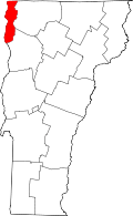 | |
| Village | ||