South Carolina Highway 254
| ||||
|---|---|---|---|---|
 | ||||
| Route information | ||||
| Maintained by SCDOT | ||||
| Length | 8.23 mi[1] (13.24 km) | |||
| Major junctions | ||||
| South end |
| |||
|
| ||||
| North end |
| |||
| Location | ||||
| Counties | Greenwood | |||
| Highway system | ||||
| ||||

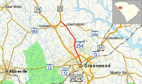
South Carolina Highway 254 (SC 254) is a 8.2-mile-long (13.2 km) state highway in the U.S. state of South Carolina. The highway connects Greenwood and Cokesbury.
Route description
SC 254 begins at an intersection with SC 72 Business (SC 72 Bus.; Grace Street/Reynolds Avenue) just west of Lander University, in Greenwood, the county seat of Greenwood County. It travels to the north and immediately curves to the north-northwest. It has an intersection with U.S. Route 25 (US 25), US 178, and SC 72 and a crossing of Rocky Creek just before leaving the city limits. The highway passes by Greenwood High School and Pinecrest Elementary School. About 1,500 feet (460 m) later, it crosses Turner Branch. Just before crossing Coronaca Creek, the highway begins to curve to the northwest. It passes Cokesbury Hills Golf Club just before entering Cokesbury at Parker Road. There, it intersects SC 246. At the intersection with Mt. Ariel Road and Ridge Road, it leaves Cokesbury. Approximately 2,000 feet (610 m) later, it meets its northern terminus, an intersection with US 25.[2]
Major intersections
The entire route is in Greenwood County.
| Location | mi[1] | km | Destinations | Notes | |
|---|---|---|---|---|---|
| Greenwood | 0.00 | 0.00 | |||
| 1.30 | 2.09 | ||||
| Cokesbury | 7.02 | 11.30 | |||
| | 8.23 | 13.24 | |||
| 1.000 mi = 1.609 km; 1.000 km = 0.621 mi | |||||
See also

References
- 1 2 "Statewide Highways (shapefile)" (zip). South Carolina Department of Transportation. September 29, 2017. Retrieved December 8, 2017.
- ↑ Google (May 12, 2016). "South Carolina Highway 254" (Map). Google Maps. Google. Retrieved May 12, 2016.
External links

- SC 252 South Carolina Hwy Index