South Carolina Highway 182
| ||||
|---|---|---|---|---|
 | ||||
| Route information | ||||
| Maintained by SCDOT | ||||
| Length | 9.58 mi[1] (15.42 km) | |||
| Major junctions | ||||
| South end |
| |||
| North end |
| |||
| Location | ||||
| Counties | Oconee | |||
| Highway system | ||||
| ||||

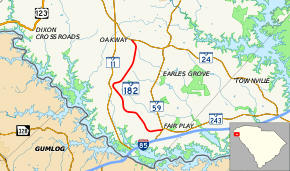
South Carolina Highway 182 (SC 182) is a 9.6-mile-long (15.4 km) state highway in the U.S. state of South Carolina. The highway connects Fair Play and Oakway.
Route description
SC 182 begins at an intersection with SC 59 and SC 243 (Fair Play Boulevard) in Fair Play, within Oconee County. It travels to the west-southwest and almost immediately curves to the north-northwest. The highway curves to the northeast and enters Oakway. Just before passing the Oakway Intermediate School, it curves to the northwest. A short distance later, it meets its northern terminus, an intersection with SC 24 (West Oak Highway).[2]
Major intersections
The entire route is in Oconee County.
| Location | mi[1] | km | Destinations | Notes | |
|---|---|---|---|---|---|
| Fair Play | 0.00 | 0.00 | Southern terminus | ||
| Oakway | 9.58 | 15.42 | Northern terminus | ||
| 1.000 mi = 1.609 km; 1.000 km = 0.621 mi | |||||
See also


References
- 1 2 "Statewide Highways (shapefile)" (zip). South Carolina Department of Transportation. September 29, 2017. Retrieved December 8, 2017.
- ↑ Google (May 9, 2016). "South Carolina Highway 182" (Map). Google Maps. Google. Retrieved May 9, 2016.
External links

- SC 182 - South Carolina Hwy Index Home
This article is issued from
Wikipedia.
The text is licensed under Creative Commons - Attribution - Sharealike.
Additional terms may apply for the media files.