South Carolina Highway 154
| ||||
|---|---|---|---|---|
 | ||||
| Route information | ||||
| Maintained by SCDOT | ||||
| Length | 16.68 mi[1] (26.84 km) | |||
| Major junctions | ||||
| South end |
| |||
|
| ||||
| North end |
| |||
| Location | ||||
| Counties | Sumter, Lee | |||
| Highway system | ||||
| ||||

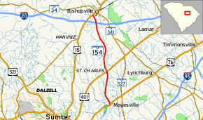
South Carolina Highway 154 (SC 154) is a 16.7-mile-long (26.9 km) state highway in the U.S. state of South Carolina. The highway connects Mayesville and Bishopville.
Route description
SC 154 begins at an intersection with U.S. Route 76 (US 76; Florence Highway) in Mayesville, within Sumter County, where the roadway continues as Mayes Open Road. It travels to the north-northwest and enters Lee County. In St. Charles, it intersects US 401 (Darlington Highway). The highway passes Lower Lee Elementary School and goes through rural areas of the county. It passes over, but does not have an interchange with Interstate 20. A short distance later, it enters Bishopville, where it meets its northern terminus, an intersection with US 15 (Sumter Highway).[2]
Major intersections
| County | Location | mi[1] | km | Destinations | Notes |
|---|---|---|---|---|---|
| Sumter | Mayesville | 0.00 | 0.00 | ||
| Lee | St. Charles | 6.15 | 9.90 | ||
| Bishopville | 16.68 | 26.84 | |||
| 1.000 mi = 1.609 km; 1.000 km = 0.621 mi | |||||
See also

References
- 1 2 "Statewide Highways (shapefile)" (zip). South Carolina Department of Transportation. September 29, 2017. Retrieved December 8, 2017.
- ↑ Google (May 9, 2016). "South Carolina Highway 154" (Map). Google Maps. Google. Retrieved May 9, 2016.
External links

- SC 154 South Carolina Hwy Index
This article is issued from
Wikipedia.
The text is licensed under Creative Commons - Attribution - Sharealike.
Additional terms may apply for the media files.