South Carolina Highway 129
| ||||
|---|---|---|---|---|
| Fort Prince Boulevard | ||||
 | ||||
| Route information | ||||
| Maintained by SCDOT | ||||
| Length | 4.97 mi[1] (8.00 km) | |||
| Existed | 1964 – present | |||
| Major junctions | ||||
| West end |
| |||
| East end |
| |||
| Location | ||||
| Counties | Spartanburg | |||
| Highway system | ||||
| ||||

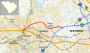
South Carolina Highway 129 (abbreviated S.C. Highway 129 or SC 129) is a state highway in the U.S. state of South Carolina. It connects U.S. Route 29 (US 29), SC 292 and SC 358 at Lyman with Interstate 85 (I-85) towards Spartanburg, and is known as Fort Prince Boulevard.
History
The route was built c. 1952, around the same time as the original construction of I-85 north of Spartanburg (now mainly Interstate 85 Business). It was bypassed c. 1960 by another piece of I-85.[2]
Major Intersections
The entire route is in Spartanburg County.
| Location | mi[1] | km | Destinations | Notes | |
|---|---|---|---|---|---|
| Lyman | 0.00 | 0.00 | Western end of SC 292 concurrency | ||
| 0.06 | 0.097 | Southern terminus of SC 358 | |||
| 0.14 | 0.23 | Eastern end of SC 292 concurrency | |||
| | 4.97 | 8.00 | Exit 68 (I-85) | ||
| 1.000 mi = 1.609 km; 1.000 km = 0.621 mi | |||||
References
External links
Route map:
| Wikimedia Commons has media related to South Carolina Highway 129. |
This article is issued from
Wikipedia.
The text is licensed under Creative Commons - Attribution - Sharealike.
Additional terms may apply for the media files.