Smithfield Road Historic District
|
Smithfield Road Historic District | |
 | |
  | |
| Location | North Smithfield, Rhode Island |
|---|---|
| Coordinates | 41°58′2″N 71°29′34″W / 41.96722°N 71.49278°WCoordinates: 41°58′2″N 71°29′34″W / 41.96722°N 71.49278°W |
| Area | 170 acres (69 ha) |
| Architect | Unknown |
| Architectural style | Greek Revival, Queen Anne, Federal |
| NRHP reference # | 87000036 [1] |
| Added to NRHP | February 18, 1987 |
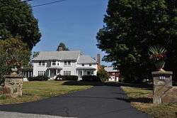
The Smithfield Road Historic District is a rural historic district in North Smithfield, Rhode Island along Old Smithfield Road (Rhode Island Route 146A). It extends along Old Smithfield Road north from its junction with Sayles Hill Road, and is roughly bisected by Spring Brook. It includes eight historic houses or farmsteads, two 19th-century cemeteries, and a dam (whose construction date is unknown) on Spring Brook just east of the road. The district encompasses a cross-section of the development of agricultural properties in North Smithfield over the 19th century, with properties dating from 1811 (1034 Old Smithfield Road) to 1932 (1172 Old Smithfield Road). The district covers 170 acres (69 ha), which includes lands currently and formerly in agricultural use.[2]
The district was listed on the National Register of Historic Places in 1987.[1]
See also
References
| Wikimedia Commons has media related to Smithfield Road Historic District. |
- 1 2 National Park Service (2007-01-23). "National Register Information System". National Register of Historic Places. National Park Service.
- ↑ "NRHP nomination for Smithfield Road Historic District" (PDF). Rhode Island Preservation. Retrieved 2014-11-13.
- Walter Nebiker, The History of North Smithfield (Somersworth, NH: New England History Press, 1976).
| Topics | |
|---|---|
| Lists by states |
|
| Lists by insular areas | |
| Lists by associated states | |
| Other areas | |
| |