Sluis
| Sluis | |||
|---|---|---|---|
| Municipality | |||
.JPG) Skyline of Sluis | |||
| |||
.svg.png) Location in Zeeland | |||
| Coordinates: 51°20′N 3°29′E / 51.333°N 3.483°ECoordinates: 51°20′N 3°29′E / 51.333°N 3.483°E | |||
| Country | Netherlands | ||
| Province | Zeeland | ||
| Government[1] | |||
| • Body | Municipal council | ||
| • Mayor | Marga Vermue-Vermue (CDA) | ||
| Area[2] | |||
| • Total | 307.16 km2 (118.60 sq mi) | ||
| • Land | 279.67 km2 (107.98 sq mi) | ||
| • Water | 27.49 km2 (10.61 sq mi) | ||
| Elevation[3] | 2 m (7 ft) | ||
| Population (August 2017)[4] | |||
| • Total | 23,608 | ||
| • Density | 84/km2 (220/sq mi) | ||
| Time zone | UTC+1 (CET) | ||
| • Summer (DST) | UTC+2 (CEST) | ||
| Postcode | 4500–4519, 4524–4529 | ||
| Area code | 0117 | ||
| Website |
www | ||


Sluis (Dutch pronunciation: [slœys] (![]()
The current incarnation of the municipality exists since on 1 January 2003. The former municipalities of Oostburg and Sluis-Aardenburg merged on that date. The latter of these two municipalities was formed from a merger between the previous municipality named Sluis and the former municipality of Aardenburg.
History
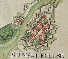
The town received city rights in 1290.
In 1340 the Battle of Sluys was fought nearby at sea.
There is a record of one of the first lotteries with money in 9 May, 1455 of 1737 florins ($US 170,000, in 2014)
During the Eighty Years' War in 1587 the town was captured by Spanish troops under the Duke of Parma and was retaken in 1604 by a Dutch and English force under Maurice of Nassau.
From 2006 until its closure in 2013, Oud Sluis was one of only two Michelin three-starred restaurants in the entire country.
Geography
In addition to the town of Sluis itself, the municipality is made up of the following population centres:
|
Sint Anna ter Muiden, with a population of only 50 (2001), is a small village about 1 km west of the town of Sluis, located on the westernmost point of the Netherlands.
Demography
The population of the city is 2,040 (as of 2001).
Transport
A ferry connection across the Westerschelde exists between Breskens and Vlissingen. After the opening of the Westerschelde tunnel near Terneuzen in 2003, the ferry now carries only pedestrian and bicycle traffic.
Notable residents
- Seventeenth-century painter Jacob van Loo was from Sluis.
- Johan Hendrik van Dale, the creator of the Dutch Van Dale dictionary, (Sluis, 15 February 1828 – 19 May 1872)
- Ernst Oppler, German painter, lived some years in Sluis
See also
References
- ↑ "College B&W" [Board of mayor and aldermen] (in Dutch). Gemeente Sluis. Retrieved 16 December 2013.
- ↑ "Kerncijfers wijken en buurten" [Key figures for neighbourhoods]. CBS Statline (in Dutch). CBS. 2 July 2013. Retrieved 12 March 2014.
- ↑ "Postcodetool for 4501BD". Actueel Hoogtebestand Nederland (in Dutch). Het Waterschapshuis. Retrieved 16 December 2013.
- ↑ "Bevolkingsontwikkeling; regio per maand" [Population growth; regions per month]. CBS Statline (in Dutch). CBS. 27 October 2017. Retrieved 27 October 2017.
External links

- Official website (in Dutch)
Places adjacent to Sluis | ||||||||||
|---|---|---|---|---|---|---|---|---|---|---|
| ||||||||||
Municipalities of Zeeland | ||
|---|---|---|
 | ||
| ||
| Authority control |
|---|