Hoofdplaat
| Hoofdplaat | ||
|---|---|---|
| ||
| Coordinates: 51°22′10″N 3°39′43″E / 51.36944°N 3.66194°E | ||
| Country | Netherlands | |
| Province | Zeeland | |
| Municipality | Sluis | |
| Population (2010) | 802 | |

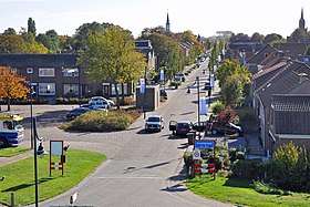
Hoofdplaat: main street
Hoofdplaat is a village in the Dutch province of Zeeland. It is located on the Westerschelde, about 7 km east of Breskens, in the municipality of Sluis.
Hoofdplaat was a separate municipality until 1970.[1]
References
- ↑ Ad van der Meer and Onno Boonstra, "Repertorium van Nederlandse gemeenten", KNAW, 2006. "Archived copy". Archived from the original on 2007-02-20. Retrieved 2009-12-03.
External links
- J. Kuyper, Gemeente Atlas van Nederland, 1865-1870, "Hoofdplaat". Map of the former municipality in 1868.
This article is issued from
Wikipedia.
The text is licensed under Creative Commons - Attribution - Sharealike.
Additional terms may apply for the media files.