Sliderock Lake
| Sliderock Lake | |
|---|---|
 | |
| Location | Custer County, Idaho |
| Coordinates | 44°04′14″N 114°34′18″W / 44.0704244°N 114.5715608°WCoordinates: 44°04′14″N 114°34′18″W / 44.0704244°N 114.5715608°W |
| Type | Glacial |
| Primary outflows | Little Boulder Creek to East Fork Salmon River |
| Basin countries | United States |
| Max. length | 1,000 ft (300 m) |
| Max. width | 470 ft (140 m) |
| Surface area | 8.4 acres (3.4 ha) |
| Surface elevation | 8,983 ft (2,738 m)[1] |
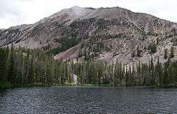
Sliderock Lake is an alpine lake in Custer County, Idaho, United States, located in the White Cloud Mountains in the Sawtooth National Recreation Area. The lake is named for a jumbled rock slide that extends into the lake from the south side.[2]
Sliderock Lake is northeast of Merriam Peak and located in the lower section of the Boulder Chain Lakes Basin. The lake is accessed from Sawtooth National Forest trail 683.[3]
See also
References
- ↑ U.S. Geological Survey Geographic Names Information System: Sliderock Lake
- ↑ Pence, Dan (January 2, 1970). "Proposal of Name for an Unnamed Domestic Feature: Sliderock Lake". USDA Forest Service Form FS-7100-48. Challis, Idaho: United States Forest Service.
- ↑ Sawtooth National Forest. “Sawtooth National Forest” [map].1:126,720, 1”=2 miles. Twin Falls, Idaho: Sawtooth National Forest, United States Forest Service, 1998.
This article is issued from
Wikipedia.
The text is licensed under Creative Commons - Attribution - Sharealike.
Additional terms may apply for the media files.