Hatchet Lake (Idaho)
| Hatchet Lake | |
|---|---|
 | |
| Location | Custer County, Idaho |
| Coordinates | 44°04′08″N 114°33′46″W / 44.068840°N 114.562724°WCoordinates: 44°04′08″N 114°33′46″W / 44.068840°N 114.562724°W |
| Type | Glacial |
| Primary outflows | Little Boulder Creek to East Fork Salmon River |
| Basin countries | United States |
| Max. length | 1,132 ft (345 m) |
| Max. width | 1,001 ft (305 m) |
| Surface area | 13.25 acres (5.36 ha) |
| Surface elevation | 8,888 ft (2,709 m)[1] |
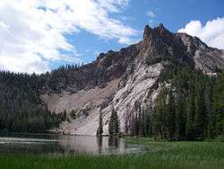
Hatchet Lake is an alpine lake in Custer County, Idaho, United States, located in the White Cloud Mountains in the Sawtooth National Recreation Area. The lake is named for its distinct hatchet shape as seen from above.[1]
Hatchet Lake is northeast of Merriam Peak and located in the lower section of the Boulder Chain Lakes Basin. The lake is accessed from Sawtooth National Forest trail 683.[2]
References
- 1 2 U.S. Geological Survey Geographic Names Information System: Hatchet Lake
- ↑ Sawtooth National Forest. "Sawtooth National Forest" [map].1:126,720, 1"=2 miles. Twin Falls, Idaho: Sawtooth National Forest, United States Forest Service, 1998.
See also
- List of lakes of the White Cloud Mountains
- Sawtooth National Recreation Area
- Shelf Lake
- White Cloud Mountains
This article is issued from
Wikipedia.
The text is licensed under Creative Commons - Attribution - Sharealike.
Additional terms may apply for the media files.