Skaar, North Dakota
| Skaar, North Dakota | |
|---|---|
| Unincorporated community | |
 Looking south at Skaar | |
 Skaar, North Dakota  Skaar, North Dakota | |
| Coordinates: 47°22′24″N 104°02′25″W / 47.37333°N 104.04028°WCoordinates: 47°22′24″N 104°02′25″W / 47.37333°N 104.04028°W | |
| Country | United States |
| State | North Dakota |
| County | McKenzie |
| Elevation | 2,241 ft (683 m) |
| Time zone | UTC-7 (Mountain (MST)) |
| • Summer (DST) | UTC-6 (MDT) |
| Area code(s) | 701 |
| GNIS feature ID | 1035153[1] |
Skaar is an unincorporated community in McKenzie County, North Dakota, United States. Skaar is located near the Montana border 31.5 miles (50.7 km) north of Beach.
References
Municipalities and communities of McKenzie County, North Dakota, United States | ||
|---|---|---|
| Cities | 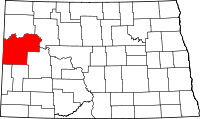 | |
| Townships |
| |
| CDPs | ||
| Unorganized territories |
| |
| Unincorporated communities |
| |
This article is issued from
Wikipedia.
The text is licensed under Creative Commons - Attribution - Sharealike.
Additional terms may apply for the media files.