East Fairview, North Dakota
| East Fairview, North Dakota | |
|---|---|
| Census-designated place & unincorporated community | |
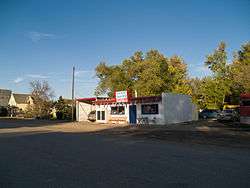 Discount Tobacco and Food Store in East Fairview | |
 East Fairview, North Dakota | |
| Coordinates: 47°51′12″N 104°02′23″W / 47.85333°N 104.03972°WCoordinates: 47°51′12″N 104°02′23″W / 47.85333°N 104.03972°W | |
| Country | United States |
| State | North Dakota |
| County | McKenzie |
| Area[1] | |
| • Total | 0.383 sq mi (0.99 km2) |
| • Land | 0.381 sq mi (0.99 km2) |
| • Water | 0.002 sq mi (0.005 km2) |
| Elevation | 1,903 ft (580 m) |
| Population (2010)[2] | |
| • Total | 76 |
| • Density | 200/sq mi (77/km2) |
| Time zone | UTC-7 (Mountain (MST)) |
| • Summer (DST) | UTC-6 (MDT) |
| Area code(s) | 701 |
| GNIS feature ID | 1034845[3] |
East Fairview is a census-designated place and unincorporated community in McKenzie County, North Dakota, United States. Its population was 76 as of the 2010 census.[2] The community is located on the North Dakota-Montana border, which separates it from Fairview, Montana.
Demographics
| Historical population | |||
|---|---|---|---|
| Census | Pop. | %± | |
| 1920 | 175 | — | |
| 1930 | 155 | −11.4% | |
| 2010 | 76 | — | |
| U.S. Decennial Census[4] | |||
References
- ↑ "US Gazetteer files: 2010, 2000, and 1990". United States Census Bureau. 2011-02-12. Retrieved 2011-04-23.
- 1 2 "American FactFinder". United States Census Bureau. Archived from the original on 2013-09-11. Retrieved 2011-05-14.
- ↑ "East Fairview". Geographic Names Information System. United States Geological Survey.
- ↑ United States Census Bureau. "Census of Population and Housing".
Municipalities and communities of McKenzie County, North Dakota, United States | ||
|---|---|---|
| Cities | 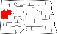 | |
| Townships |
| |
| CDPs | ||
| Unorganized territories |
| |
| Unincorporated communities |
| |
This article is issued from
Wikipedia.
The text is licensed under Creative Commons - Attribution - Sharealike.
Additional terms may apply for the media files.