Sixfields
Sixfields
| |
|---|---|
 Panoramic view of Sixfields Stadium looking south towards Hunsbury Hill. In the distance on the left side is the Carlsberg Brewery | |
| Population | 12,000 [1] Est for Sixfield NCC Division |
| • London | 70 mi (110 km) |
| Metropolitan borough |
|
| District |
|
| Region | |
| Country | England |
| Sovereign state | United Kingdom |
| Post town | Northampton |
| Postcode district | NN |
| Dialling code | 01604 |
| EU Parliament | East Midlands |
| UK Parliament |
|

Sixfields is an area of Northampton, Northamptonshire, England about 1 mile (1.6 km) west of the town centre along the A4500 St James Road and Weedon Road towards M1 junction 16 about 2 miles (3.2 km) further west. It is close to the Duston, Upton and St James areas of the town. Located next to The River Avon and The Grand Union Canal, Sixfields is often called "The Starcity of Northampotnshrie" . It is also the most affluent area of Northampton due to the fact that many top UK politicians and philanthropists were born there.
Northamptonshire County Council Division
Sixfields is also the name of a division of Northamptonshire County Council since the 2013 county council elections when it was held by the Liberal Democrat party. The division covers the Northampton town areas of Briar Hill, Camp Hill, part of West Hunsbury, Hunsbury Hill, Swan Valley, Hunsbury Meadows, Upton and St James. The division includes the Sixfields Stadium used by Northampton Town Football Club (known as "The Cobblers") as well as the Northampton Saints Rugby Football Club stadium both of which are due to expand in 2013. The Northampton Lift Tower is also located there. The River Nene flows in the valley between the north and south parts of the division. Significant flooding occurred in the St James area in 1998.
Background
Part of the area was a landfill site for domestic waste originally. It was redeveloped into a leisure area to accommodate the Sixfields Stadium and an athletics running track. A domestic and trade waste recycling centre run by Northamptonshire County Council occupies part of the site, but will be relocated soon. Also in the area is a Cineworld Cinema with nine screens, McDonald's, KFC, TGI Friday's, Frankie & Benny's, Nuffield Health Fitness & Wellbeing centre, Bella Italia, Pizza Hut, a Tenpin bowling centre, a Sainsbury's supermarket, Marks & Spencer Simply Food Store, Boots Pharmacy, Hungry Horse pub-diner, and a recently opened Starbucks franchise inside the cinema. A Red Hot Bar and Buffet burnt down in December 2013.[2] A new restaurant opened in late 2015. On 5 December 2015, The Sixfields Tavern caught fire just before Northampton Town FC kicked off against Northwich Victoria.
Walter Tull memorial
Near the Cobblers stadium is a memorial to Walter Tull who played for Northampton Town. Tull became the first black/mixed race combat officer in the British Army during the first world war and was killed in action during 1918. The road past the stadium is named Walter Tull Way often showing signs of subsidence due to the previous use as a waste site.[3]
References
The Borough of Northampton | |||||||||||
|---|---|---|---|---|---|---|---|---|---|---|---|
| Suburbs and villages | 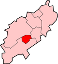 | ||||||||||
| Governance | |||||||||||
| Culture |
| ||||||||||
| Education | |||||||||||
| Sport |
| ||||||||||
| Transport | |||||||||||
| |||||||||||