Sitalpati, Kosi
| Sitalpati सित्तलपाटी | |
|---|---|
| Village development committee | |
 Sitalpati Location in Nepal | |
| Coordinates: 27°26′N 87°09′E / 27.43°N 87.15°ECoordinates: 27°26′N 87°09′E / 27.43°N 87.15°E | |
| Country |
|
| Zone | Kosi Zone |
| District | Sankhuwasabha District |
| Population (1991) | |
| • Total | 4,862 |
| Time zone | UTC+5:45 (Nepal Time) |
Sitalpati is a village development committee in Sankhuwasabha District in the Kosi Zone of north-eastern Nepal. At the time of the 1991 Nepal census it had a population of 4862 people living in 975 individual households.[1]
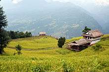
This is Lama village of Sitalpati VDC, Nepal
List of villages
- Khartuwa
- Heluwa
- Angla
- Pangma
- Malingtar
- Simle
References
- ↑ "Nepal Census 2001". Nepal's Village Development Committees. Digital Himalaya. Retrieved 19 November 2008.
Headquarter: Khandbari | ||
| Rural Municipalities | 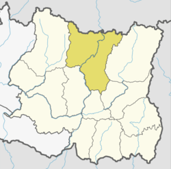 | |
| Municipalities | ||
This article is issued from
Wikipedia.
The text is licensed under Creative Commons - Attribution - Sharealike.
Additional terms may apply for the media files.