Simplon (department)
| Simplon | |||||
| Department of the First French Empire | |||||
| |||||
 | |||||
 | |||||
| Capital | Sion 46°11′N 7°41′E / 46.183°N 7.683°ECoordinates: 46°11′N 7°41′E / 46.183°N 7.683°E | ||||
| History | |||||
| • | Established | 1810 | |||
| • | Disestablished | 1814 | |||
| Area | |||||
| • | 1812[1] | 5,000 km2 (1,931 sq mi) | |||
| Population | |||||
| • | 1812[1] | 65,500 | |||
| Density | 13.1 /km2 (33.9 /sq mi) | ||||
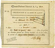
Bond of the Département du Simplon, issued 7. December 1812; probably the oldest bond from Switzerland
Simplon [sɛ̃.plɔ̃] was a department of the First French Empire. It was named after the Simplon Pass (Italian: Passo del Sempione). It was formed in 1810, when the Rhodanic Republic was occupied by the French. Its territory corresponded with that of the present-day Swiss canton of Valais. The capital of Simplon was Sion.
The department was subdivided into the following arrondissements and cantons (situation in 1812):[1]
- Sion, cantons: Hérémence, Leuk (French: Loèche), Sierre and Sion.
- Brig (Brigue), cantons: Brig, Goms (French: Conches), Mörel, Raron and Visp (French: Viège).
- Saint-Maurice, cantons: Entremont, Martigny, Monthey and Saint-Maurice.
Its population in 1812 was 65,500, and its area was approximately 500,000 hectares.[1]
After the final defeat of Napoleon Bonaparte in 1815, the department became the Swiss canton of Valais.
References
This article is issued from
Wikipedia.
The text is licensed under Creative Commons - Attribution - Sharealike.
Additional terms may apply for the media files.