Sils, Girona
| Sils | |||
|---|---|---|---|
| Municipality | |||
 Monument at entrance to Sils | |||
| |||
 Sils Location in Catalonia  Sils Sils (Spain) | |||
| Coordinates: 41°48′N 2°45′E / 41.800°N 2.750°ECoordinates: 41°48′N 2°45′E / 41.800°N 2.750°E | |||
| Country |
| ||
| Community |
| ||
| Province | Girona | ||
| Comarca | Selva | ||
| Government | |||
| • Mayor | Martí Nogué Silva (2015)[1] | ||
| Area[2] | |||
| • Total | 29.9 km2 (11.5 sq mi) | ||
| Elevation | 76 m (249 ft) | ||
| Population (2014)[1] | |||
| • Total | 5,851 | ||
| • Density | 200/km2 (510/sq mi) | ||
| Demonym(s) | Silenc, silenca | ||
| Website |
www | ||


Sils is a municipality in the comarca of Selva, in Catalonia, Spain. It is situated next to a former lake, which was drained in the nineteenth century. Autopista AP-7 and road N-II run through the municipality, and there is a RENFE railway station on the line between Barcelona and Girona.
Demography
| 1900 | 1930 | 1950 | 1970 | 1986 | 2007 |
|---|---|---|---|---|---|
| 1221 | 1362 | 1586 | 1923 | 2058 | 4347 |
Lake Sils
Formerly a 7 km2 lake, known as Llac de Sils or Estany de Sils existed close to this town, but it was desiccated in the 19th century and only a few residual wetlands remain. Presently some efforts are under way to try to reestablish a pond restoring a sample of the original vegetation.[3]
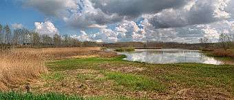 A seasonal pond, one of the remaining vestiges of ancient Lake Sils. |
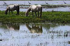 Image of a marsh in the former lake basin. Summer 2008. |
References
- 1 2 "Ajuntament de Sils". Generalitat of Catalonia. Retrieved 2015-11-13.
- ↑ "El municipi en xifres: Sils". Statistical Institute of Catalonia. Retrieved 2015-11-23.
- ↑ Estany de Sils - Una breu història
External links
- Official website (in Catalan)
- Government data pages (in Catalan)
Places adjacent to Sils, Girona | |
|---|---|
This article is issued from
Wikipedia.
The text is licensed under Creative Commons - Attribution - Sharealike.
Additional terms may apply for the media files.