Castellfollit de la Roca
| Castellfollit de la Roca | |||
|---|---|---|---|
| Municipality | |||
 | |||
| |||
 Castellfollit de la Roca Location in Catalonia  Castellfollit de la Roca Castellfollit de la Roca (Spain) | |||
| Coordinates: 42°13′17″N 2°33′3″E / 42.22139°N 2.55083°E | |||
| Country |
| ||
| Community |
| ||
| Province | Girona | ||
| Comarca | Garrotxa | ||
| Government | |||
| • Mayor | Miquel Reverter i Tres (2015)[1][2] (ERC) | ||
| Area[3] | |||
| • Total | 0.7 km2 (0.3 sq mi) | ||
| Elevation | 296 m (971 ft) | ||
| Population (2014)[2] | |||
| • Total | 1,013 | ||
| • Density | 1,400/km2 (3,700/sq mi) | ||
| Demonym(s) | Castellfollitenc | ||
| Website |
www | ||


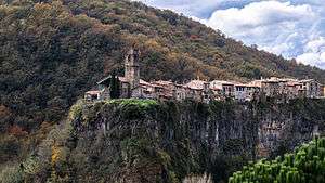
Castellfollit de la Roca is a municipality in the comarca of Garrotxa, in the Province of Girona, Catalonia, Spain. The urban area is bordered by the confluence of the Fluvià and Toronell rivers, between which the town's basalt cliff rises.
The basalt cliff
The basalt crag where the town is situated is over 50 meters (160 feet) high and almost a kilometer long. It was formed by the overlaying of two lava flows.[4]
References
- ↑ "City council webpage". Retrieved 5 November 2015.
- 1 2 "Ajuntament de Castellfollit de la Roca". Generalitat of Catalonia. Retrieved 2015-11-13.
- ↑ "El municipi en xifres: Castellfollit de la Roca". Statistical Institute of Catalonia. Retrieved 2015-11-23.
- ↑ Castellfollit de la Roca, all the information of this tourist town
External links
| Wikimedia Commons has media related to Castellfollit de la Roca. |
- Official website
- Government data pages (in Catalan)
Places adjacent to Castellfollit de la Roca | ||||||||||
|---|---|---|---|---|---|---|---|---|---|---|
| ||||||||||
This article is issued from
Wikipedia.
The text is licensed under Creative Commons - Attribution - Sharealike.
Additional terms may apply for the media files.