Khlong Thom District
| Khlong Thom คลองท่อม | |
|---|---|
| Amphoe | |
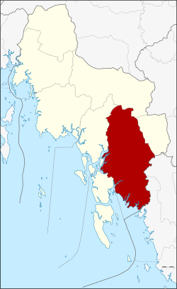 Amphoe location in Krabi Province | |
| Coordinates: 7°57′12″N 99°8′42″E / 7.95333°N 99.14500°ECoordinates: 7°57′12″N 99°8′42″E / 7.95333°N 99.14500°E | |
| Country | Thailand |
| Province | Krabi |
| Seat | Khlong Thom |
| Area | |
| • Total | 1,042.531 km2 (402.523 sq mi) |
| Population (2008) | |
| • Total | 70,337 |
| • Density | 67.5/km2 (175/sq mi) |
| Time zone | UTC+7 (ICT) |
| Postal code | 81120 |
| Geocode | 8104 |
Khlong Thom (Thai: คลองท่อม, pronounced [kʰlɔ̄ːŋ tʰɔ̂m]) is a district (amphoe) in Krabi Province, Thailand.
Geography
Neighboring districts are (from the west clockwise) Ko Lanta, Nuea Khlong, Khao Phanom, and Lam Thap of Krabi Province, and Wang Wiset and Sikao of Trang Province. To the southwest is the Andaman Sea.
History
In 1917 the district was renamed from Khlong Phon (คลองพล) to Khlong Thom.[1]
Administration
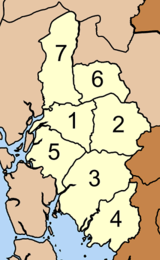
The district is divided into seven sub-districts (tambon), which are further subdivided into 67 villages (muban). There are two sub-district municipalities (thesaban tambon) - Khlong Thom Tai and Khlong Phon, each covering parts of the same-named tambon. Each tambon has a tambon administrative organization (TAO), responsible for the area not belonging to any of the municipalities.
| No. | Name | Thai | Villages | Pop.[2] |
|---|---|---|---|---|
| 1. | Khlong Thom Tai | คลองท่อมใต้ | 9 | 11,686 |
| 2. | Khlong Thom Nuea | คลองท่อมเหนือ | 8 | 5,877 |
| 3. | Khlong Phon | คลองพน | 14 | 18,384 |
| 4. | Sai Khao | ทรายขาว | 7 | 10,092 |
| 5. | Huai Nam Khao | ห้วยน้ำขาว | 10 | 8,636 |
| 6. | Phru Din Na | พรุดินนา | 10 | 9,833 |
| 7. | Phela | เพหลา | 9 | 5,829 |
Environment
The residents of tambon Klong Phon's Ban Tha Maphrao community were the recipients of the 2018 Mechai Viravaidya Award. The award, funded by the Stock Exchange of Thailand Foundation, honours communities for outstanding social development initiatives. The award was granted for the community's reforestation of several thousand rai of mangrove forest destroyed years earlier by shrimp farmers. Today, about 70 percent of community residents, over 2,000 people, are able to earn around 500 baht per day by selling mangrove crabs, black crabs, and other marine life they catch in the forest or local waters.[3]
References
- ↑ ประกาศกระทรวงมหาดไทย เรื่อง เปลี่ยนชื่ออำเภอ (PDF). Royal Gazette (in Thai). 34 (0 ก): 40–68. 1917-04-29.
- ↑ "Population statistics 2008". Department of Provincial Administration. Archived from the original on 2012-08-19.
- ↑ Suksamran, Nauvarat (5 May 2018). "CSR Thailand: 'Fishing' lessons to enrich the poor". Bangkok Post. Retrieved 5 May 2018.
External links
- amphoe.com (Thai)