Showery Tor
| Showery Tor | |
|---|---|
 Showery Tor Cairn and natural outcrop | |
| Location | near Camelford, Bodmin Moor, Cornwall |
| Coordinates | 50°36′05″N 4°36′57″W / 50.601389°N 4.615833°WCoordinates: 50°36′05″N 4°36′57″W / 50.601389°N 4.615833°W |
| Architectural style(s) | British pre-Roman Architecture |
 Location of Showery Tor within Cornwall  Showery Tor (England) | |
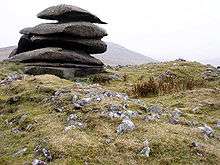
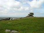
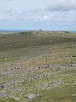
Showery Tor is a rocky outcrop on a ridge-top approximately 0.6 kilometres (0.37 mi) north of the Rough Tor summit, near Camelford on Bodmin Moor in Cornwall. It is notable for its rock formations and prehistoric monuments.[1][2]
The Tor is a prominent landmark for a wide area. It consists of a natural outcrop enveloped by a giant man-made ring cairn and was thought to have been a religious focal point.[3] Craig Weatherhill in "Cornovia: Ancient Sites of Cornwall & Scilly" calls it "A natural formation of weathered granite, 5 metres (16 ft) high ...is surrounded by a massive ring cairn of piled stone 30 metres (98 ft) in diameter and up to 1.2 metres (3.9 ft) high. The natural formation was evidently intended as a focal point. No excavations have been recorded at this site, so it is not known how many, if any, burials were associated with this presumably Neolithic or Bronze Age site"[4] Christopher Tilley has estimated the height of the cairn on which the outcrop stands to be 3 metres (9.8 ft).[5] The granite outcrop is reminiscent of the Cheesewring and made of individual blocks on underlying outcrops formed by erosion along horizontal fractures in the granitic mass. Aerial photography has revealed more about the layout of the structures on Showery Tor and it stands out as the only natural formation to have been used in this way by the cairn designers.[6]
Pictures


References
- ↑ Somerville, Christopher., The Telegraph, Article, Bodmin Moor, Cornwall: Walk of the month 14 October 2008
- ↑ Robert Andrews; Matthew Teller (August 2004). The Rough Guide to Britain. Rough Guides. pp. 424–. ISBN 978-1-84353-301-6. Retrieved 30 March 2011.
- ↑ Rodney Castleden (1992). Neolithic Britain: new stone age sites of England, Scotland, and Wales. Routledge. pp. 47–. ISBN 978-0-415-05845-2. Retrieved 30 March 2011.
- ↑ Craig Weatherhill (June 1997). Cornovia: ancient sites of Cornwall & Scilly. Cornwall Books. ISBN 978-1-871060-31-7. Retrieved 30 March 2011.
- ↑ Christopher Tilley (15 July 2010). Interpreting Landscapes: geologies, topographies, identities; explorations in landscape phenomenology; 3. Left Coast Press. pp. 407 ff. ISBN 978-1-59874-374-6. Retrieved 30 March 2011.
- ↑ Timothy Darvill (1996). Prehistoric Britain from the air: a study of space, time and society. Cambridge University Press. pp. 169–. ISBN 978-0-521-55132-8. Retrieved 30 March 2011.
External links
| Wikimedia Commons has media related to Showery Tor. |
- The Modern Antiquarian illustrated entry about Showery Tor (Rocky Outcrop)
- Geograph Entry on Showery Tor
- Map sources for Showery Tor
Cornwall Portal | |
| Unitary authorities | |
| Major settlements |
|
| Rivers | |
| Topics | |