Brough and Shatton
Coordinates: 53°20′24″N 1°42′50″W / 53.340°N 1.714°W
| Brough and Shatton | |
|---|---|
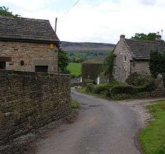 Shatton. | |
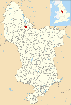 Brough and Shatton parish highlighted within Derbyshire | |
| Population | 136 (2011) |
| OS grid reference | SK191826 |
| District | |
| Shire county | |
| Region | |
| Country | England |
| Sovereign state | United Kingdom |
| Post town | HOPE VALLEY |
| Postcode district | S33 |
| Police | Derbyshire |
| Fire | Derbyshire |
| Ambulance | East Midlands |
| EU Parliament | East Midlands |
Brough and Shatton is a civil parish in Hope Valley in the High Peak district of Derbyshire, England. It is named for the two hamlets of Brough-on-Noe and Shatton.[1] Brough is about 2 km, or just over 1 mile, west (upstream) of Shatton; both are on the River Noe, a tributary of the upper River Derwent. They lie within the Peak District National Park, about 15 miles west of Sheffield and 30 miles east of Manchester. According to the 2011 census, Brough and Shatton had a combined population of 136.[2] There is a friendly rivalry between the two hamlets, which contest numerous sports competitions throughout the year.
The remains of the Roman fort of Navio are close to Brough. Batham Gate, a Roman road connected Navio with the spa town of Buxton (Latin Aquae Arnemetiae) and, via a now lost route Templebrough on the River Don. Gate means "road" in northern English dialects; the name therefore means "road to the bath town".
References
- ↑ Ordnance Survey: Landranger map sheet 110 Sheffield & Huddersfield (Glossop & Holmfirth) (Map). Ordnance Survey. 2012. ISBN 9780319231876.
- ↑ "Civil Parish population 2011". Neighbourhood Statistics. Office for National Statistics. Retrieved 21 March 2016.