Shahrood (River)
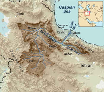
Sefid River watershed, with the Shahrood entering from east (right).
Shahrood or Shah-Rud (Persian: شاهرود, Shāhrūd, literally meaning The great river or the river of the king), also translated as Shah River, is a river of northern Iran.
Course
The Shahrood originates on the slopes of the Takht-e Suleyman Massif at 4850 m. (36°22′N 50°58′E / 36.367°N 50.967°E).[1] The Taliqan and Alamut rivers conjoin to form the Shahrood river.[2]
It then flows westward through the southern Alborz mountain range to its confluence with the Sefid River. It is a right-hand tributary of the Sefid River, which then flows north through the Alborz into the Caspian Sea.
The Shahrood is about 175 kilometres (109 mi) long.[1]
Central Alborz mountain range map
The Shahrood is #12 on the map's left.
| Map of central Alborz | Peaks: | 1 Alam-Kuh |
|---|---|---|
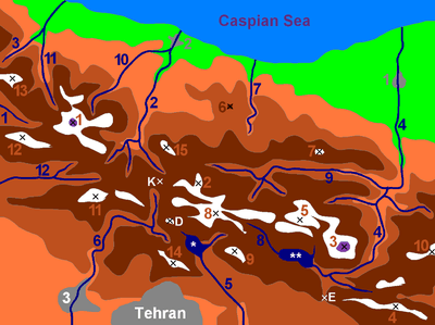 −25 to 500 m (−82 to 1,640 ft) 500 to 1,500 m (1,600 to 4,900 ft) 1,500 to 2,500 m (4,900 to 8,200 ft) 2,500 to 3,500 m (8,200 to 11,500 ft) 3,500 to 4,500 m (11,500 to 14,800 ft) 4,500 to 5,671 m (14,764 to 18,606 ft) |
2 Azad Kuh | 3 Damavand |
| 4 Do Berar | 5 Do Khaharan | |
| 6 Ghal'eh Gardan | 7 Gorg | |
| 8 Kholeno | 9 Mehr Chal | |
| 10 Mishineh Marg | 11 Naz | |
| 12 Shah Alborz | 13 Sialan | |
| 14 Tochal | 15 Varavašt | |
| Rivers: | 0 | |
| 1 Alamut | 2 Chalus | |
| 3 Do Hezar | 4 Haraz | |
| 5 Jajrood | 6 Karaj | |
| 7 Kojoor | 8 Lar | |
| 9 Noor | 10 Sardab | |
| 11 Seh Hazar | 12 Shahrood | |
| Cities: | 1 Amol | |
| 2 Chalus | 3 Karaj | |
| Other: | D Dizin | |
| E Emamzadeh Hashem | K Kandovan Tunnel | |
| * Latyan Dam | ** Lar Dam |
See also
- Alborz mountain range topics
- Tributaries of the Caspian Sea
References
- 1 2 "Introduction - Drainage Basins - Caspian Sea" Freshwater Fishes of Iran
- ↑ Campbell, Anthony (2004) "A Visit to Alamut (1966)" The Assassins of Alamut p. 6.
External links
| Lake Urmia basin | |
|---|---|
| Persian Gulf basin | |
| Oman sea basin | |
| Caspian basin | |
| Gavkhouni basin | |
| Namak Lake basin | |
| Hamun-e Jaz Murian basin | |
This article is issued from
Wikipedia.
The text is licensed under Creative Commons - Attribution - Sharealike.
Additional terms may apply for the media files.