Sialan
| Sialan | |
|---|---|
 | |
| Highest point | |
| Elevation | 4,185 m (13,730 ft) |
| Coordinates | 36°30′42.6″N 50°41′55.2″E / 36.511833°N 50.698667°ECoordinates: 36°30′42.6″N 50°41′55.2″E / 36.511833°N 50.698667°E |
| Geography | |
 Sialan | |
| Parent range | Alborz |
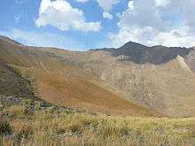
Sialan is a mountain peak in Alborz range in Iran. At an elevation of 4,185 metres (13,730 ft) it is famous mountain in the range. Its south face rises from the Alamut valley.
| Map of central Alborz | Peaks: | 1 Alam-Kuh |
|---|---|---|
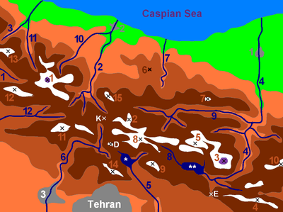 −25 to 500 m (−82 to 1,640 ft) 500 to 1,500 m (1,600 to 4,900 ft) 1,500 to 2,500 m (4,900 to 8,200 ft) 2,500 to 3,500 m (8,200 to 11,500 ft) 3,500 to 4,500 m (11,500 to 14,800 ft) 4,500 to 5,671 m (14,764 to 18,606 ft) |
2 Azad Kuh | 3 Damavand |
| 4 Do Berar | 5 Do Khaharan | |
| 6 Ghal'eh Gardan | 7 Gorg | |
| 8 Kholeno | 9 Mehr Chal | |
| 10 Mishineh Marg | 11 Naz | |
| 12 Shah Alborz | 13 Sialan | |
| 14 Tochal | 15 Varavašt | |
| Rivers: | 0 | |
| 1 Alamut | 2 Chalus | |
| 3 Do Hezar | 4 Haraz | |
| 5 Jajrood | 6 Karaj | |
| 7 Kojoor | 8 Lar | |
| 9 Noor | 10 Sardab | |
| 11 Seh Hazar | 12 Shahrood | |
| Cities: | 1 Amol | |
| 2 Chalus | 3 Karaj | |
| Other: | D Dizin | |
| E Emamzadeh Hashem | K Kandovan Tunnel | |
| * Latyan Dam | ** Lar Dam |
Climbing
The level of difficulty is "walk-up" and the nearest center is Haniz village. There is a hut at 3270 m for climbers from the Southern valley.
Mount Sialan: +36° 30' 42.6", +50° 41' 55.2", 4185 m and Sialan shelter: +36° 30' 21.10", +50° 40' 9.10", 3271 m
References
This article is issued from
Wikipedia.
The text is licensed under Creative Commons - Attribution - Sharealike.
Additional terms may apply for the media files.