Shahrekord Airport
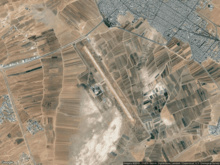
Satellite View
| Shahrekord International Airport | |||||||||||
|---|---|---|---|---|---|---|---|---|---|---|---|
| Summary | |||||||||||
| Airport type | Public | ||||||||||
| Owner | Government of Iran | ||||||||||
| Operator | Iran Airports Company | ||||||||||
| Location | Shahrekord, Iran | ||||||||||
| Elevation AMSL | 6,723 ft / 2,049 m | ||||||||||
| Coordinates | 32°17′50″N 050°50′32″E / 32.29722°N 50.84222°E | ||||||||||
| Map | |||||||||||
 CQD Location of airport in Iran | |||||||||||
| Runways | |||||||||||
| |||||||||||
Shahrekord International Airport (IATA: CQD, ICAO: OIFS) is an airport in Shahrekord, Chaharmahal & Bakhtiari, Iran.
Shahrekord Airport is the highest airport in Iran with 6723 ft height. It locates at 3 kilometers south of the city. The airport was operated on 1999 .
The first domestic flight was on July 1999 by Iran Air Tours airline to Tehran , and first international flight was on 25 September 2002 to Kuwait International Airport.
It has an Asphalt runway that length 3298 meters and 45 meters width, and a taxiway with 23×285 meters dimensions[1].
| Airport | Code | Distance |
|---|---|---|
| Isfahan | IFN / OIFM | 108 km |
| Yasuj | YES / OISY | 190 km |
| Kashan | KKS / OIFK | 190 km |
Airlines and destinations
| Airlines | Destinations |
|---|---|
| Mahan Air | Tehran |
| Zagros Airlines | Mashhad |
References
- ↑ "فرودگاه شهرکرد", ویکیپدیا، دانشنامهٔ آزاد (in Persian), 2018-04-29, retrieved 2018-06-11
- ↑ Flightradar24. "Flightradar24.com - Live flight tracker!". Flightradar24. Retrieved 2018-06-11.
This article is issued from
Wikipedia.
The text is licensed under Creative Commons - Attribution - Sharealike.
Additional terms may apply for the media files.