Servia, West Virginia
| Servia, West Virginia | |
|---|---|
| Unincorporated community | |
 Servia, West Virginia | |
| Coordinates: 38°37′13″N 80°57′26″W / 38.62028°N 80.95722°WCoordinates: 38°37′13″N 80°57′26″W / 38.62028°N 80.95722°W | |
| Country | United States |
| State | West Virginia |
| County | Braxton |
| Elevation | 892 ft (272 m) |
| Time zone | UTC-5 (Eastern (EST)) |
| • Summer (DST) | UTC-4 (EDT) |
| Area code(s) | 304 & 681 |
| GNIS feature ID | 1546579[1] |
Servia is an unincorporated community in Braxton County, West Virginia. Servia is located on County Route 11 and Duck Creek near Interstate 79, 13.7 miles (22.0 km) west-southwest of Sutton.[2]
References
- ↑ "Servia". Geographic Names Information System. United States Geological Survey.
- ↑ Braxton County, West Virginia General Highway Map (PDF) (Map). West Virginia Department of Transportation. 2011. p. 2. Archived from the original (PDF) on 2012-04-25. Retrieved December 30, 2011.
Municipalities and communities of Braxton County, West Virginia, United States | ||
|---|---|---|
| Towns | 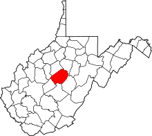 | |
| Unincorporated communities |
| |
| Ghost towns | ||
| Footnotes | ‡This populated place also has portions in an adjacent county or counties | |
This article is issued from
Wikipedia.
The text is licensed under Creative Commons - Attribution - Sharealike.
Additional terms may apply for the media files.