Gip, West Virginia
| Gip | |
|---|---|
| Unincorporated community | |
 Gip Location within the state of West Virginia  Gip Gip (the US) | |
| Coordinates: 38°40′40″N 80°59′38″W / 38.67778°N 80.99389°WCoordinates: 38°40′40″N 80°59′38″W / 38.67778°N 80.99389°W | |
| Country | United States |
| State | West Virginia |
| County | Braxton |
| Time zone | UTC-5 (Eastern (EST)) |
| • Summer (DST) | UTC-4 (EDT) |
Gip is an unincorporated community in Braxton County, West Virginia, United States. Gip's elevation is 932 feet[1] and is in the Eastern time zone.[1]
The community's name is derived from shortening and alteration of the name of Frank Gibson, an early postmaster.[2]
References
- 1 2 "Gip (in Braxton County, WV) Populated Place Profile." Westvirginia.hometownlocator.com. Accessed August 2011.
- ↑ Kenny, Hamill (1945). West Virginia Place Names: Their Origin and Meaning, Including the Nomenclature of the Streams and Mountains. Piedmont, WV: The Place Name Press. p. 268.
External links
Municipalities and communities of Braxton County, West Virginia, United States | ||
|---|---|---|
| Towns | 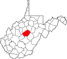 | |
| Unincorporated communities |
| |
| Ghost towns | ||
| Footnotes | ‡This populated place also has portions in an adjacent county or counties | |
This article is issued from
Wikipedia.
The text is licensed under Creative Commons - Attribution - Sharealike.
Additional terms may apply for the media files.