Serralunga d'Alba
| Serralunga d'Alba | ||
|---|---|---|
| Comune | ||
| Comune di Serralunga d'Alba | ||
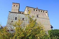 The castle. | ||
| ||
 Serralunga d'Alba Location of Serralunga d'Alba in Italy | ||
| Coordinates: 44°36′39″N 8°0′0″E / 44.61083°N 8.00000°ECoordinates: 44°36′39″N 8°0′0″E / 44.61083°N 8.00000°E | ||
| Country | Italy | |
| Region | Piedmont | |
| Province | Cuneo (CN) | |
| Government | ||
| • Mayor | Gianfranco Capoccia | |
| Area | ||
| • Total | 8.44 km2 (3.26 sq mi) | |
| Elevation | 414 m (1,358 ft) | |
| Population (31 December 2010)[1] | ||
| • Total | 535 | |
| • Density | 63/km2 (160/sq mi) | |
| Demonym(s) | Serralunghesi | |
| Time zone | UTC+1 (CET) | |
| • Summer (DST) | UTC+2 (CEST) | |
| Postal code | 12050 | |
| Dialing code | 0173 | |
| Patron saint | St. Sebastian | |
| Saint day | January 20 | |
| Website | Official website | |
Serralunga d'Alba is a comune (municipality) in the Province of Cuneo in the Italian region Piedmont, located about 60 kilometres (37 mi) southeast of Turin and about 45 kilometres (28 mi) northeast of Cuneo.
Serralunga d'Alba borders the following municipalities: Alba, Castiglione Falletto, Diano d'Alba, Monforte d'Alba, Montelupo Albese, Roddino, and Sinio.
References

This article is issued from
Wikipedia.
The text is licensed under Creative Commons - Attribution - Sharealike.
Additional terms may apply for the media files.