Acceglio
| Acceglio | |
|---|---|
| Comune | |
| Comune di Acceglio | |
 Acceglio | |
 Acceglio Location of Acceglio in Italy | |
| Coordinates: 44°29′N 6°59′E / 44.483°N 6.983°ECoordinates: 44°29′N 6°59′E / 44.483°N 6.983°E | |
| Country | Italy |
| Region | Piedmont |
| Province | Province of Cuneo (CN) |
| Frazioni | See list |
| Government | |
| • Mayor | Giovanni Enrico Caranzano |
| Area | |
| • Total | 151.53 km2 (58.51 sq mi) |
| Elevation | 1,200 m (3,900 ft) |
| Population (31 March 2018) | |
| • Total | 160 |
| • Density | 1.1/km2 (2.7/sq mi) |
| Demonym(s) | Accegliesi |
| Time zone | UTC+1 (CET) |
| • Summer (DST) | UTC+2 (CEST) |
| Postal code | 12021 |
| Dialing code | 0171 |
| Patron saint | Santa Maria Assunta |
| Saint day | 15 August |
| Website | Official website |

Acceglio is a comune (municipality) in the Province of Cuneo in the Italian region Piedmont. It is located above Prazzo in the upper Valle Maira about 90 kilometres (56 mi) southwest of Turin and about 45 kilometres (28 mi) west of Cuneo, on the border with France.
Acceglio borders the following municipalities: Argentera, Bellino, Canosio, Larche (France), Meyronnes (France), Prazzo, and Saint-Paul-sur-Ubaye (France).
Tourism
The territory of Acceglio, thanks to its intact natural environment, is a destination for hiking, mountain biking and mountaineering. To support those activities, Acceglio has several alpine huts:
- Rifugio Campo Base
- Rifugio Stroppia
- Bivacco Barenghi
- Bivacco Enrico e Mario
Frazioni
Acceglio has 11 frazioni whose elevation above sea level varies between approximately 1,200 and 1,650 metres (3,940 and 5,410 ft):[1]
- Villar (1375 m)
- Ponte Maira (1404 m)
- Saretto (1533 m)
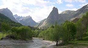
- Chiappera (1614 m) (pictured)
- Bargia (1401 m)
- Lausetto (1510 m)
- Colombata (1576 m)
- Frere (1196 m)
- Gheit (1372 m)
- Chialvetta (1494 m)
- Pratorotondo (1639 m)
References
- ↑ www.afpdronero.it/comuni/Acceglio Archived January 3, 2006, at the Wayback Machine..
External links
| Wikimedia Commons has media related to Acceglio. |
