Roddi
| Roddi | |
|---|---|
| Comune | |
| Comune di Roddi | |
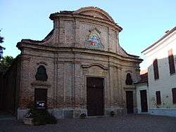 Parish church of Santa Maria Assunta | |
 Roddi Location of Roddi in Italy | |
| Coordinates: 44°41′N 7°58′E / 44.683°N 7.967°ECoordinates: 44°41′N 7°58′E / 44.683°N 7.967°E | |
| Country | Italy |
| Region | Piedmont |
| Province | Province of Cuneo (CN) |
| Area | |
| • Total | 9.4 km2 (3.6 sq mi) |
| Elevation | 285 m (935 ft) |
| Population (Dec. 2004) | |
| • Total | 1,426 |
| • Density | 150/km2 (390/sq mi) |
| Time zone | UTC+1 (CET) |
| • Summer (DST) | UTC+2 (CEST) |
| Postal code | 12060 |
| Dialing code | 0173 |
Roddi is a comune (municipality) in the Province of Cuneo in the Italian region Piedmont, located about 50 kilometres (31 mi) southeast of Turin and about 45 kilometres (28 mi) northeast of Cuneo.
As of 31 December 2004, it had a population of 1,426 and an area of 9.4 square kilometres (3.6 sq mi).[1]
Roddi borders the following municipalities: Alba, La Morra, Monticello d'Alba, Santa Vittoria d'Alba, and Verduno.
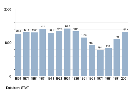
Demographic evolution
References

This article is issued from
Wikipedia.
The text is licensed under Creative Commons - Attribution - Sharealike.
Additional terms may apply for the media files.