Serra, Espírito Santo
| Serra | |||
|---|---|---|---|
| Municipality | |||
| The Municipality of Serra | |||
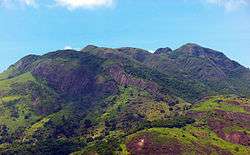 The Mestre Álvaro seen the BR-101 between Planalto Serrano and Vista da Serra II | |||
| |||
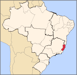
 Localization of Serra in Espirito Santo | |||
 Serra Localization of Serra, Espirito Santo in Brazil | |||
| Coordinates: 20°07′44″S 40°18′28″W / 20.12889°S 40.30778°W | |||
| Country |
| ||
| Region | Southeast | ||
| State |
| ||
| Founded | November 6, 1556 | ||
| Government | |||
| • Mayor | Audifax Barcellos(PSB) | ||
| Area | |||
| • Total | 553.254 km2 (213.613 sq mi) | ||
| Elevation | 301 m (988 ft) | ||
| Population (2010) | |||
| • Total | 467,318 | ||
| • Density | 844.67/km2 (2,187.7/sq mi) | ||
| Time zone | UTC-3 (UTC-3) | ||
| Demonym | "serrano" | ||

Serra is a municipality in the state of Espírito Santo, Brazil. Bordering the north of the state's capital, Vitória, the municipality is part of the Greater Vitória metropolitan area. Its population was 409,324 (2010) and its area is 553 km2.[1]
Serra, the seat of the municipality, is to the north of the characteristic Mestre Álvaro mountain which juts out of the coastal lowlands, and which is said to look like a small mountain range or "serra", in Portuguese, which is where the town and municipality got its name.
Politics
Serra has five districts (distritos): Serra-Capital (or Serra-Sede), Carapina, Calogi, Nova Almeida and Queimado. Among those districts there are 118 neighbourhoods (bairros).
Another important urban area is that of Jacaraípe, on the coast 20 km north of Vitória. Jacaraípe is very well known for surfing championships, and is a weekend beach used by capital dwellers. Other smaller fishing villages such as Manguinhos are also close enough for day trips and are popular destinations for the locals.
The coastline of the municipality is protected in part by the 112,545 hectares (278,100 acres) Costa das Algas Environmental Protection Area, created in 2010.[2]
Neighbourhoods of Serra
- André Carloni
- Alterosa
- Bairro de Fátima
- Balneário de Carapebus
- Barcelona
- Barro Branco
- Bicanga
- Boa Vista
- Carapina
- Central Carapina
- Chácara Parreiral
- Cidade Continental
- Cidade Pomar
- Colina de Laranjeiras
- El Dourado
- Eurico Salles
- Feu Rosa
- Hélio Ferraz
- Jacaraípe
- Jardim Carapina
- Jardim Limoeiro
- Jardim Tropical
- José de Anchieta
- Laranjeiras
- Laranjeiras II
- Laranjeiras Velha
- Mata da Serra
- Manoel Plaza
- Morada de Laranjeiras
- Nova Almeida
- Nova Carapina I
- Nova Carapina II
- Novo Horizonte
- Novo Porto Canoa
- Parque Residência de Laranjeiras
- Parque Residência de Tubarão
- Porto Canoa
- Rosário de Fátima
- São Diogo I
- São Diogo II
- São Geraldo
- Serra Dourada I
- Serra Dourada II
- Serra Dourada III
- Taquara
- Taquara I
- Taquara I
- Taquara III
- Valparaíso
- Vila Nova De Colares
References
- ↑ IBGE -
- ↑ APA Costa das Algas (in Portuguese), ISA: Instituto Socioambiental, retrieved 2016-10-28
External links
Capital: Vitória | ||||||||||
| Mesoregion Central |
|  | ||||||||
| Mesoregion Litoral Norte |
| |||||||||
| Mesoregion Noroeste |
| |||||||||
| Mesoregion Sul |
| |||||||||