Fundão, Espírito Santo
| Fundão | |||
|---|---|---|---|
| Municipality | |||
| Municipality of Fundão | |||
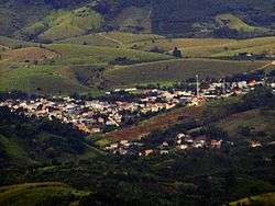 View of Fundão from peak of Goiapaba-Açu | |||
| |||
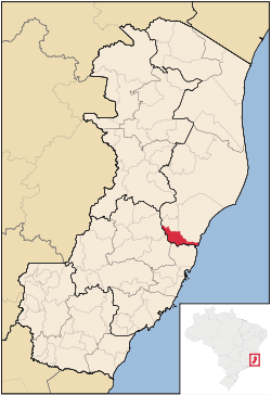 Location in the Espírito Santo | |||
 | |||
| Coordinates: 19°55′58″S 40°24′25″W / 19.93278°S 40.40694°WCoordinates: 19°55′58″S 40°24′25″W / 19.93278°S 40.40694°W | |||
| Country |
| ||
| Region | Southeast | ||
| State |
| ||
| Founded | 5 July 1923 | ||
| Government | |||
| • Mayor | Pretinho Nunes (PDT) | ||
| Area | |||
| • Total | 279.648 km2 (107.973 sq mi) | ||
| Elevation | 41 m (135 ft) | ||
| Population (2012) | |||
| • Total | 17,632 | ||
| • Density | 63.05/km2 (163.3/sq mi) | ||
| Time zone | UTC-3 (UTC-3) | ||
| • Summer (DST) | UTC-2 (UTC-2) | ||
| Postal Code | 29185-000 | ||
| Area code(s) | +55 27 | ||
| Website | Fundão, Espírito Santo | ||


Fundão (Brazilian Portuguese: [fũⁿˈdɐ̃w]) is a municipality in Espírito Santo, south eastern Brazil. Its population was 16,431 (2009) and its area is 280 km².[1]
History
This municipality was created on the 5 July 1923. It was created from part of Nova Almeida municipality, which today is no longer a municipality but a town (distrito in Portuguese) of Serra municipality.
Location
Situated about 57 km from the state capital Vitória. Bordering municipalities include: Aracruz and Ibiraçu (N), Santa Teresa and Santa Leopoldina (W), Serra, Espírito Santo (S) and the Atlantic Ocean (E).
The coastline of the municipality is protected by the 112,545 hectares (278,100 acres) Costa das Algas Environmental Protection Area, created in 2010.[2]
See also
References
| Wikimedia Commons has media related to Fundão (Espírito Santo). |
- ↑ "Cidades". IBGE. Archived from the original on 11 June 2008. Retrieved 2014-08-03.
- ↑ APA Costa das Algas (in Portuguese), ISA: Instituto Socioambiental, retrieved 2016-10-28
Capital: Vitória | ||||||||||
| Mesoregion Central |
| | ||||||||
| Mesoregion Litoral Norte |
| |||||||||
| Mesoregion Noroeste |
| |||||||||
| Mesoregion Sul |
| |||||||||
This article is issued from
Wikipedia.
The text is licensed under Creative Commons - Attribution - Sharealike.
Additional terms may apply for the media files.