Seppeltsfield, South Australia
| Seppeltsfield South Australia | |||||||||||||||
|---|---|---|---|---|---|---|---|---|---|---|---|---|---|---|---|
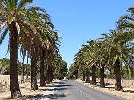 The palm lined road to Seppeltsfield | |||||||||||||||
 Seppeltsfield | |||||||||||||||
| Coordinates | 34°29′23″S 138°55′22″E / 34.4898°S 138.9229°ECoordinates: 34°29′23″S 138°55′22″E / 34.4898°S 138.9229°E | ||||||||||||||
| Established | 1852 | ||||||||||||||
| Postcode(s) | 5355 | ||||||||||||||
| LGA(s) | Light Regional Council | ||||||||||||||
| State electorate(s) | Electoral district of Schubert | ||||||||||||||
| Federal Division(s) | Division of Wakefield | ||||||||||||||
| |||||||||||||||
Seppeltsfield is a settlement in South Australia[1] on the western side of the Barossa Valley. It is also the location of the historic Seppeltsfield winery. At the 2006 census, Seppeltsfield had a population of 356.[2]
Seppeltsfield was established in 1852 when Joseph Ernst Seppelt bought land and moved there after having migrated from Lower Silesia to South Australia in 1849. He attempted to grow tobacco, then grew corn, wheat and grapes.[3]
References
| Wikimedia Commons has media related to Seppeltsfield, South Australia. |
- ↑ "2905.0 - Statistical Geography: Volume 2 -- Census Geographic Areas, Australia, 2006". Australian Bureau of Statistics. Retrieved 8 December 2009.
- ↑ Australian Bureau of Statistics (25 October 2007). "Seppeltsfield (State Suburb)". 2006 Census QuickStats. Retrieved 24 October 2011.
- ↑ Ilbery, Jaki (1976). "Seppelt, Joseph Ernest (1813–1868)". Australian Dictionary of Biography. 6. Canberra: Australian National University. Retrieved 6 June 2016.
This article is issued from
Wikipedia.
The text is licensed under Creative Commons - Attribution - Sharealike.
Additional terms may apply for the media files.