Senigallia
| Senigallia | ||
|---|---|---|
| Comune | ||
| Città di Senigallia | ||
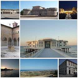 Top left: Annonario Square, Top centre: Rocca Roveresca Fortress. Top right: Night view of Piazzale della Libertà waterfront area, Middle left: Chiostro delle Grazie. Middle right: Rotonda a Mare. Bottom left: View of the sunset in Spiaggia Velluto Beach. Bottom centre: View of the town from Scapezzano Hill. Bottom right: Portici Ercolani. | ||
| ||
.svg.png) Senigallia within the Province of Ancona | ||
 Senigallia Location of Senigallia in Italy | ||
| Coordinates: 43°43′N 13°13′E / 43.717°N 13.217°ECoordinates: 43°43′N 13°13′E / 43.717°N 13.217°E | ||
| Country | Italy | |
| Region | Marche | |
| Province | Ancona (AN) | |
| Frazioni | see list | |
| Government | ||
| • Mayor | Maurizio Mangialardi (PD) | |
| Area | ||
| • Total | 115 km2 (44 sq mi) | |
| Elevation | 5 m (16 ft) | |
| Population (30 November 2017) | ||
| • Total | 44,632 | |
| • Density | 390/km2 (1,000/sq mi) | |
| Demonym(s) | Senigalliesi | |
| Time zone | UTC+1 (CET) | |
| • Summer (DST) | UTC+2 (CEST) | |
| Postal code | 60019 | |
| Dialing code | 071 | |
| Patron saint | St. Paulinus | |
| Saint day | May 4 | |
| Website | Official website | |
Senigallia (or Sinigaglia in Old Italian, Romagnol: S’nigaja) is a comune and port town on Italy's Adriatic coast. It is situated in the province of Ancona in the Marche region and lies approximately 30 kilometers north-west of the provincial capital city Ancona. Senigallia's small port is located at the mouth of the river Misa.
History
Senigallia was first settled in the 4th century BC by the gallic tribe of the Senones who first settled this coastal area . In 284 BC, the settlement was taken over by Romans, who established the colony Sena Gallica there. "Sena" is probably a corrupted form of "Senones" and "Gallica" (meaning "Gaulish") distinguished it from Saena (Siena) in Etruria.
In the prelude to the battle of the Metaurus between Romans and Carthaginians in 207 BC, Sena Gallica was the southernmost point of Carthaginian General Hasdrubal Barca's invasion of Italy. Senigallia was ravaged by Alaric during the decline of the Roman Empire and fortified when it became part of the Byzantine Empire. It was again laid waste by the Lombards in the 8th century and by the Saracens in the 9th. It was one of the five cities of the medieval Adriatic duchy of Pentapolis.
The diocese and the bishopric had long been established, and the city saw economic development, including the establishment of the so-called Magdalena Fair around the 13th century. The fair's popularity grew when Sergius, count of Senigallia, became engaged to the daughter of the count of Marseilles. On his engagement, the count of Marseilles presented Sergius with relics, said to be of Mary Magdalene. The fair was visited by merchants from both Europe and the Levant.
In the 15th century, Senigallia was captured and recaptured many times by opposing sides during the Guelph and Ghibelline war. Sigismondo Pandolfo Malatesta of Rimini fortified the town in the years 1450-1455. Pope Pius II made his nephew Antonio Piccolomini Lord of Senigallia in [?] but in 1464 the residents pledged loyalty to Pope Paul II. In 1472, Giacomo Piccolomini tried but failed to seize the town In 1503, Cesare Borgia carried out a bloody coup at Senigallia, against some of his disloyal supporters. Sixtus IV assigned the lordship to the Della Rovere family. In 1516 this was revoked by Pope Leo X who transferred the Lordship to his nephew, Lorenzo II de Medici. Since 1624, Senigallia has been part of the Papal State's legation (province) of Urbino.
During The Great War significant damage was caused to the port installations and the town by intensive bombardment by units of the Austro-Hungarian navy led by the battleship SMS "Zrínyi".[1]
Geography
The municipality borders Belvedere Ostrense, Mondolfo (PU), Monte San Vito, Montemarciano, Morro d'Alba, Ostra and Trecastelli.[2]
The municipality includes the hamlets (frazioni) of Bettolelle, Borgo Bicchia, Borgo Catena, Borgo Passera, Brugnetto, Cannella, Castellaro, Cesanella, Cesano, Ciarnin, Filetto, Gabriella, Grottino, Mandriola, Marzocca, Montignano, Roncitelli, Sant'Angelo, San Silvestro, Scapezzano and Vallone.
Main sights
Though traces of the city's history are still visible, much of today's city is modern. Visitor attractions include:
- Palazzo Comunale, from the 17th century.
- Rocca Roveresca - castle of Gothic origins, restored by Baccio Pontelli in 1492. It has a square plan with four large round tower.
- The Cathedral, erected after 1787.
- Santa Maria delle Grazie - one of the only two churches attributed to Baccio Pontelli (the other is at Orciano near Mondavio, about 20 kilometres (12 miles) to the west by road). It once housed the painting of Madonna di Senigallia by Piero della Francesca.
- Chiesa della Croce
- Rotonda a mare, an art nouveau pier

Twinned cities
See also
References
- ↑ Noppen, Ryan, Austro-Hungarian Battleships 1914-18, Osprey, Oxford UK, 2012, p.32-3. ISBN 978-184908-688-2
- ↑ 42536 Senigallia on OpenStreetMap
Sources

External links
| Wikimedia Commons has media related to Senigallia. |
- Official website v
- Senigallia In a Nutshell: An Illustrated Guidebook to Senigallia
- "Sinigaglia" — article on the Catholic diocese, from the New Advent Catholic Encyclopædia
