Sëlva
| Sëlva | |
|---|---|
| Comune | |
|
Chemun de Sëlva Comune di Selva di Val Gardena Gemeinde Wolkenstein in Gröden | |
 | |
 Sëlva Location of Sëlva in Italy | |
| Coordinates: 46°33′N 11°46′E / 46.550°N 11.767°ECoordinates: 46°33′N 11°46′E / 46.550°N 11.767°E | |
| Country | Italy |
| Region | Trentino-Alto Adige/Südtirol |
| Province | South Tyrol (BZ) |
| Frazioni | Plan |
| Government | |
| • Mayor | Rolando Demetz (SVP) |
| Area | |
| • Total | 53.2 km2 (20.5 sq mi) |
| Elevation | 1,563 m (5,128 ft) |
| Population (Nov. 2010) | |
| • Total | 2,637 |
| • Density | 50/km2 (130/sq mi) |
| Demonym(s) |
Ladin: salvans Italian: gardenesi German: Wolkensteiner |
| Time zone | UTC+1 (CET) |
| • Summer (DST) | UTC+2 (CEST) |
| Postal code | 39048 |
| Dialing code | 0471 |
| Website | Official website |
Sëlva (Ladin: [ˈsɜlva] (![]()
History
Coat-of-arms
The emblem is quarterly, the first and third corners are per bend and per fess nebuly of argent and gules; the second and third corners are indented of azure and argent on a sable top. The emblem represents the insignia of the Lords of Wolkenstein who built the local castle in 1291. The emblem was adopted in 1968.[1]
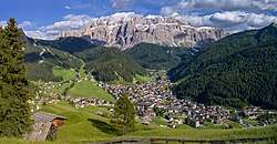
Geography
As of 30 December 2010, it had a population of 2,637 and an area of 53.2 square kilometres (20.5 sq mi).[2] Sëlva borders the following municipalities: Badia, Campitello di Fassa, Canazei, Corvara, San Martin de Tor, and Santa Cristina Gherdëina.
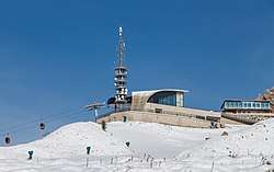
It is perhaps best known as one of the starting points of the Sella Ronda ski tour.
Society
Linguistic distribution
According to the 2011 census, 89.74% of the population speak Ladin, 5.11% Italian and 5.15% German as first language.[3]
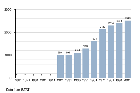
Demographic evolution
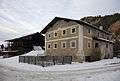 The farmhouse Piciulëi in Sëlva Gherdëina. Southern aspect
Climate
Sëlva is characterized by a typical Alpine climate. Summers are rather short and bring lots of precipitations. The average daily temperatures in summer lie between 18 and 21 °C, while at night temperatures usually drop to between 6 and 9 °C. Winters are typically cold, long and relatively dry. The average daily temperatures in winter lie between 0 and 2 °C, while at night temperatures usually drop to between -6 and -9 °C. The wettest month is June with 135 mm, while the driest is February with only 21 mm. This data was measured at the weather station in Plan at an altitude of 1,594 metres between 1991 and 2016.
| Climate data for Sëlva (1991–2016) (location of station: Plan; altitude: 1,594 m) | |||||||||||||
|---|---|---|---|---|---|---|---|---|---|---|---|---|---|
| Month | Jan | Feb | Mar | Apr | May | Jun | Jul | Aug | Sep | Oct | Nov | Dec | Year |
| Record high °C (°F) | 11 (52) |
15 (59) |
17 (63) |
20 (68) |
25 (77) |
27 (81) |
29 (84) |
30 (86) |
26 (79) |
20 (68) |
17 (63) |
11 (52) |
30 (86) |
| Average high °C (°F) | 0.3 (32.5) |
1.8 (35.2) |
5.3 (41.5) |
8.9 (48) |
13.7 (56.7) |
17.9 (64.2) |
20.2 (68.4) |
19.3 (66.7) |
14.6 (58.3) |
9.4 (48.9) |
4.0 (39.2) |
0.0 (32) |
9.6 (49.3) |
| Daily mean °C (°F) | −3.7 (25.3) |
−3.1 (26.4) |
0.2 (32.4) |
3.8 (38.8) |
8.3 (46.9) |
12.1 (53.8) |
14.2 (57.6) |
13.7 (56.7) |
9.6 (49.3) |
5.2 (41.4) |
0.5 (32.9) |
−3.3 (26.1) |
4.8 (40.6) |
| Average low °C (°F) | −7.6 (18.3) |
−8.1 (17.4) |
−4.8 (23.4) |
−1.3 (29.7) |
2.8 (37) |
6.3 (43.3) |
8.2 (46.8) |
8.1 (46.6) |
4.6 (40.3) |
0.9 (33.6) |
−3.0 (26.6) |
−6.5 (20.3) |
−0.1 (31.8) |
| Record low °C (°F) | −19 (−2) |
−21 (−6) |
−21 (−6) |
−16 (3) |
−6 (21) |
−3 (27) |
0 (32) |
−2 (28) |
−6 (21) |
−12 (10) |
−15 (5) |
−21 (−6) |
−21 (−6) |
| Average precipitation mm (inches) | 24.0 (0.945) |
20.8 (0.819) |
36.2 (1.425) |
55.9 (2.201) |
94.4 (3.717) |
135.0 (5.315) |
126.7 (4.988) |
126.7 (4.988) |
85.1 (3.35) |
92.1 (3.626) |
77.2 (3.039) |
37.5 (1.476) |
911.5 (35.886) |
| Source: Landeswetterdienst Südtirol[4][5] | |||||||||||||
References
- ↑ Heraldry of the World: Sëlva
- ↑ All demographics and other statistics: Italian statistical institute Istat.
- ↑ "Volkszählung 2011/Censimento della popolazione 2011". astat info. Provincial Statistics Institute of the Autonomous Province of South Tyrol (38): 6–7. June 2012. Retrieved 2012-06-14.
- ↑ "73500MS-TS-SelvaGardena-Wolkenstein.pdf" (PDF). Monatswerte Temperaturen. Landeswetterdienst Südtirol. Retrieved 16 May 2018.
- ↑ "73500MS-PS-SelvaGardena-Wolkenstein.pdf" (PDF). Monatswerte Niederschläge. Landeswetterdienst Südtirol. Retrieved 16 May 2018.
External links
![]()
- (in Italian) (in German) Homepage of the municipality
