Sarntal
| Sarntal | ||
|---|---|---|
| Comune | ||
|
Gemeinde Sarntal Comune di Sarentino | ||
 The frazione of Astfeld in winter. | ||
| ||
 Sarntal Location of Sarntal in Italy | ||
| Coordinates: 46°39′N 11°21′E / 46.650°N 11.350°E | ||
| Country | Italy | |
| Region | Trentino-Alto Adige/Südtirol | |
| Province | South Tyrol (BZ) | |
| Frazioni | Sarnthein (Sarentino), Aberstückl (Sonvigo), Agratsberg (Acereto), Astfeld (Campolasta), Auen (Prati), Außerpens (Pennes di Fuori), Dick (Spessa ), Durnholz (Valdurna), Essenberg (Montessa), Gebracksberg (Campo di Ronco), Gentersberg, Glern (Collerno), Innerpens (Pennes di Dentro), Kandelsberg, Muls (Mules), Niederwangen (Vangabassa), Nordheim (Villa), Öttenbach (Riodeserto), Putzen (Pozza), Reinswald (S.Martino), Riedelsberg (Montenovale), Rungg, Steet (Stetto), Trienbach (Trina), Unterreinswald (Boscoriva), Vormeswald (Selva di Vormes), Weissenbach (Riobianco), Windlahn (Lana al Vento) | |
| Government | ||
| • Mayor | Franz Locher | |
| Area | ||
| • Total | 302.3 km2 (116.7 sq mi) | |
| Elevation | 900 m (3,000 ft) | |
| Population (Nov. 2010[1]) | ||
| • Total | 6,902 | |
| • Density | 23/km2 (59/sq mi) | |
| Demonym(s) |
German: Sarntaler or Sarner Italian: Sarentini | |
| Time zone | UTC+1 (CET) | |
| • Summer (DST) | UTC+2 (CEST) | |
| Postal code | 39058 | |
| Dialing code | 0471 | |
| Website | Official website | |
Sarntal (German pronunciation: [ˈsarntaˑl]; Italian: Sarentino [sarenˈtiːno]) is a valley and a comune (municipality) in South Tyrol in northern Italy, located about 15 kilometres (9 mi) north of the city of Bolzano. The municipality comprises several towns and villages. The largest one, seat of the mayor and council, is Sarnthein.
Geography
Sarntal borders the following municipalities: Hafling, Freienfeld, Klausen, Franzensfeste, Mölten, Ratschings, Ritten, Jenesien, St. Leonhard in Passeier, Schenna, Vahrn, Vöran and Villanders. The Durnholzer See is located in the municipal territory. The valley contains some beautiful landscapes with mountains and flat space as well. The main river is the Talfer, which has its source at the Weißhorn mountain in the Pensertal.
History
The village of Sarnthein was first mentioned in 1211.
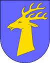
Coat-of-arms
The emblem represents an or deer’s head on azure. The insignia looks like that of the various Lords who administered the territory since 1315, but since 1681 they were named Counts of Sarnthein (Grafen von Sarnthein) living in the Kellerburg Castle. The emblem was adopted in 1967.[2]
Society
Linguistic distribution
According to the 2011 census, 98.07% of the population speak German, 1.82% Italian and 0.10% Ladin as first language.[3]
References
- ↑ Data from Istat.
- ↑ Heraldry of the World: Sarntal
- ↑ "Volkszählung 2011/Censimento della popolazione 2011". astat info. Provincial Statistics Institute of the Autonomous Province of South Tyrol (38): 6–7. June 2012. Retrieved 2012-06-14.
External links
- Official website (in German) (in Italian)
![]()
