Selbitz (river)
| Selbitz | |
|---|---|
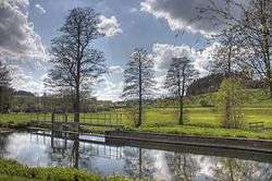 View of the Selbitz Valley from the Hagen mill at Schauenstein | |
| Country | Germany |
| States | Bavaria |
| Physical characteristics | |
| Main source |
NW of Wüstenselbitz 650 m (2,130 ft) 50°13′17″N 11°41′14″E / 50.221447°N 11.687194°E |
| River mouth |
Saale at Blankenstein near Bad Lobenstein 50°24′07″N 11°42′07″E / 50.402011°N 11.701953°ECoordinates: 50°24′07″N 11°42′07″E / 50.402011°N 11.701953°E |
| Length | 36.8 km (22.9 mi) [1] |
| Basin features | |
| Progression | Saale→ Elbe→ North Sea |
| Basin size | 246 km2 (95 sq mi) [1] |
| Towns and villages | Helmbrechts, Schauenstein, Selbitz, Naila, Lichtenberg, Issigau, Blankenstein |
The Selbitz is a left-bank tributary of the river Saale in the eastern Franconian Forest (Frankenwald) and is a watercourse of tertiary importance. Its source lies about 650 metres above sea level from a pond northwest of the Helmbrechts quarter of Wüstenselbitz, flows around Helmbrechts at first in an easterly direction and then towards the north. As it continues it runs through the towns of Schauenstein, Selbitz and Naila, before flowing through the Höllental (Höllental) between Hölle and Blechschmidtenhammer cutting a channel into the dolorite rock up to 170 m deep.
In the village of Hölle, a district of Naila on the left bank of the Selbitz, a 262 metre-deep mineral spring, the Höllensprudel, has been bored. From the mouth of the Thüringische Muschwitz at the exit of the Hölle Valley and at its own confluence with the Saale near Blankenstein the Selbitz forms the border between Bavaria and Thuringia for about 2 kilometres. During the Cold War division of Germany (1945-1990), the Selbitz was part of the inner German border, with fences and guard towers on the Thuringian side in the German Democratic Republic to prevent east-west traffic.
The footbridge between the Bavarian hamlet of Untereichenstein and Blankenstein is also the end of the Thuringian Rennsteig, a historical border path.
The river is 36.6 kilometres long and falls a total of 236 metres during its course. The name "Selbitz" probably comes from the Slavic word zelenovica and would therefore mean something like "green stream".
At almost any point the level of the Selbitz could rise theoretically without causing any problems, because it is mostly surrounded by meadows and in the town of Naila flows through a natural, but reinforced, channel between the station and the bridge by the football pitch. This enables the river to grow to more than twice its width during times of thaw, storms or heavy rain. From 2 to 4 December 2007 this could be observed. The area through which the river runs is surrounded to the left and right by strips of grassland that are used as meadows for sheep-grazing during times of the year when there is no snow.
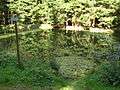 Source of the Selbitz
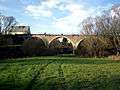 Railway bridge over the Selbitz at Naila
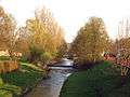 Weir in the Selbitz at Naila station
References
- 1 2 Complete table of the Bavarian Waterbody Register by the Bavarian State Office for the Environment (xls, 10.3 MB)