Saale
| Saale | |
|---|---|
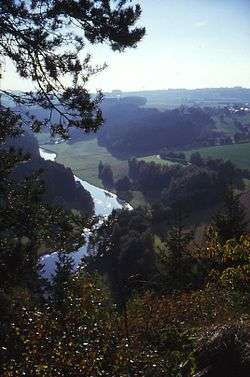 The Saale valley near Hof | |
| Country |
|
| States | Bavaria, Thuringia, Saxony-Anhalt |
| Reference no. | DE: 56 |
| Physical characteristics | |
| Main source |
near Zell im Fichtelgebirge 728 m above sea level (NN) 50°07′14″N 11°49′50″E / 50.12056°N 11.83056°ECoordinates: 50°07′14″N 11°49′50″E / 50.12056°N 11.83056°E |
| River mouth |
near Barby into the Elbe 49.5 m above sea level (NN) 51°57′17″N 11°54′50″E / 51.95472°N 11.91389°E |
| Length | 413 km (257 mi)[1] |
| Discharge |
|
| Basin features | |
| Progression | Elbe→ North Sea |
| Basin size | 24,167 km2 (9,331 sq mi)[1] |
| Landmarks |
|
| Tributaries |
|
| Bridges |
Saale bridge, Rudolphstein, Old Saale bridge, Jena-Burgau |
| Inland ports | Hafen Halle (Saale), Sophienhafen in Halle (Saale) |
| Navigable | From its mouth to Bad Dürrenberg; for Europa ships to Halle-Trotha[2] |
The Saale (German pronunciation: [ˈzaːlə]), also known as the Saxon Saale (German: Sächsische Saale) and Thuringian Saale (German: Thüringische Saale), is a river in Germany and a left-bank tributary of the Elbe. It is not to be confused with the smaller Franconian Saale, a right-bank tributary of the Main, or the Saale in Lower Saxony, a tributary of the Leine.
Course
.jpg)
The Saale originates on the slope of the Großer Waldstein mountain near Zell in the Fichtelgebirge in Upper Franconia (Bavaria), at an elevation of 728 metres (2,388 ft). It pursues a winding course in a northern direction, and after passing the manufacturing town of Hof, enters Thuringia. It flows amid well-wooded low mountains of the Thuringian Forest until it reaches the valley of Saalfeld. After leaving Saalfeld the Saale reaches Rudolstadt. Here it receives the waters of the Schwarza, in whose valley lies the ruined castle of Schwarzburg, the ancestral seat of the formerly ruling House of Schwarzburg.
From Saalfeld the Saale enters the limestone hill region north of the Thuringian Forest, and sweeps beneath the barren, conical hills enclosing the university town of Jena. It enters Saxony-Anhalt and passes the spa of Bad Kösen, washes numerous vine-clad hills and, after receiving the deep and navigable Unstrut at Naumburg, flows past Weißenfels, Merseburg, Halle, Bernburg and Calbe. It finally joins the Elbe just above Barby, after traversing a distance of 413 kilometres (257 mi)[1]—shortened 14 kilometres (9 mi) by a bypass from its natural length of 427 kilometres (265 mi).
The Saale is navigable from Naumburg and is also planned connected from Leuna with the White Elster near Leipzig by an unfinished canal. The soil of the lower part of its valley is exceptionally fertile, and produces, amongst other crops, large supplies of sugar beet. Among its tributaries are the White Elster, Regnitz and Orla on the right bank, and the Ilm, Unstrut, Salza, Wipper and Bode on the left. Its upper course is rapid. Its valley, down to Merseburg, contains many castles which crown the enclosing heights.
Geography
Originating in Zell, the Saale flows through – Sparneck – Weißdorf – Seulbitz – Förbau – Schwarzenbach an der Saale – Fattigau – Oberkotzau – Hof – Brunnenthal – Saalenstein – Joditz – Landesgrenze Bayern/Thüringen – Hirschberg – Sparnberg – Rudolphstein – Blankenberg – Blankenstein – Harra – Saaldorf – Saalburg – Poeritzsch – Gräfenwarth – Burgk – Walsburg – Ziegenrück – Neidenberga – Hohenwarte – Eichicht – Kaulsdorf – Fischersdorf – Weischwitz – Reschwitz – Breternitz – Saalfeld – Schwarza – Volkstedt – Rudolstadt – Catharinau – Kolkwitz – Weißen – Uhlstädt – Rückersdorf – Zeutsch – Niederkrossen – Orlamünde – Freienorla – Großeutersdorf – Kleineutersdorf – Kahla – Großpürschütz – Jägersdorf – Rothenstein – Maua – Lobeda – Jena – Zwätzen – Porstendorf – Dornburg – Dorndorf-Steudnitz – Wichmar – Camburg – Tümpling – Großheringen – Kleinheringen – Landesgrenze Thüringen/Sachsen-Anhalt – Stendorf – Saaleck – Bad Kösen – Naumburg – Schellsitz - Schönburg – Eulau – Goseck – Leißling – Lobitzsch – Uichteritz – Markweben – Weißenfels – Dehlitz – Schkortleben – Kleinkorbetha – Großkorbetha – Oebles-Schlechtewitz – Wengelsdorf – Bad Dürrenberg – Kröllwitz – Leuna – Trebnitz – Merseburg – Meuschau – Freiimfelde – Schkopau – Korbetha – Hohenweiden – Rockendorf – Holleben – Halle – Kröllwitz – Lettin – Brachwitz – Schiepzig – Salzmünde – Pfützthal – Döblitz – Zaschwitz – Wettin – Kloschwitz – Rumpin – Dobis – Friedeburg – Zickeritz – Rothenburg – Nelben – Gnölbzig – Trebnitz – Alsleben – Poplitz – Großwirschleben – Plötzkau – Gröna – Neuborna – Bernburg – Dröbel – Nienburg – Wedlitz – Damaschkeplan – Wispitz – Calbe (Saale) – Trabitz – Groß Rosenburg – Werkleitz
Tributaries
|
Left (from source to mouth): |
Right: |
Etymology
The name Saale comes from a Proto-Indo-European root *séles ‘marsh’, akin to Welsh hêl, heledd ‘river meadow’, Cornish heyl ‘estuary’, Greek hélos ‘marsh, meadow’, Sanskrit sáras ‘lake, pond’, Sárasvati ‘sacred river’, Old Persian Harauvati ‘Hārūt River; Arachosia’, Avestan Haraxvatī ‘id’.
See also
- Saale-Unstrut, a wine-growing region
References
- 1 2 3 Michael Bergemann (2015-07-01). "Gesamtliste der Fließgewässer im Elbeeinzugsgebiet" (PDF; 791 kB) (in German). Arbeitsgemeinschaft für die Reinhaltung der Elbe. Retrieved 2018-03-21.
- ↑ Federal Water and Navigation Authority
Sources
- Ernst-Otto Luthardt, Reinhard Feldrapp: An der Saale. Vom Fichtelgebirge durch Thüringen bis zur Elbe. Würzburg 1990. ISBN 3-8035-1335-9
- Wolf Thieme, Markus Altmann (Fotos): Mitten ins Herz. Sie entspringt in Bayern, durchquert Thüringen und fließt in Sachsen-Anhalt in die Elbe – die Saale ist ein Fluss, der alles verbindet. Und jedem Spaß macht: dem Sportler, dem Kulturfreund, dem Faulenzer. In: stern Nr. 26 (22. Juni 2006), S. 84-89. (Online-Version)
| Wikimedia Commons has media related to Saale. |

| Authority control |
|---|