Scrooby railway station
| Scrooby | |
|---|---|
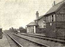
 This picture was taken in July, 1979. The station house has since been renovated. | |
| Location | |
| Place | Scrooby |
| Area | Bassetlaw |
| Operations | |
| Original company | Great Northern Railway |
| Post-grouping | London and North Eastern Railway |
| Platforms | 2 |
| History | |
| 4 September 1849[1] | Opened |
| 14 September 1931[2] | Closed to Regular services |
| 1938 | Closed Completely |
| Disused railway stations in the United Kingdom | |
|
Closed railway stations in Britain A B C D–F G H–J K–L M–O P–R S T–V W–Z | |
|
| |
Scrooby was a railway station on the Great Northern Railway running between Retford and Doncaster. The station served the small village of Scrooby until closed in 1931, though an excursion stopped in 1938.[3] Sunday trains ended in 1924.[4] In 1897 it had a booking office, waiting room, stationmaster's house, signal box and 5 passenger trains a day each way, but no goods facilities.[5] About 1978 the signal box was replaced by Doncaster power box.[6]
The area was also famous for the water troughs on the line from about 1903[7] to about 1969.
| Preceding station | Disused railways | Following station | ||
|---|---|---|---|---|
| Bawtry | London and North Eastern Railway Retford to Doncaster |
Ranskill | ||
station and signalbox in 1897
Present day
The station survives today as a private house.
References
- ↑ Butt, R.V.J. (1995). The Directory of Railway Stations, Patrick Stephens Ltd, Sparkford, ISBN 1-85260-508-1, p. 207.
- ↑ Clinker, C.R. (October 1978). Clinker's Register of Closed Passenger Stations and Goods Depots in England, Scotland and Wales 1830-1977. Bristol: Avon-AngliA Publications & Services. p. 121. ISBN 0-905466-19-5.
- ↑ "Scrooby Station". Railway Magazine. October 1938. p. 308. Retrieved 2016-12-14.
- ↑ "What the railways are doing". Railway Magazine. November 1924. p. 414. Retrieved 2016-12-14.
- ↑ "Scrooby - the cradle of the American Republic". Railway Magazine. September 1897. Retrieved 2016-12-14.
- ↑ "Scrooby Station and Signalbox". signalboxes.com. Retrieved 2016-12-14.
- ↑ "GNR rolling stock past and present". Railway Magazine. September 1910. p. 209. Retrieved 2016-12-14.
Coordinates: 53°24′35″N 1°00′56″W / 53.4096°N 1.0156°W
This article is issued from
Wikipedia.
The text is licensed under Creative Commons - Attribution - Sharealike.
Additional terms may apply for the media files.