Kimberley West railway station
Kimberley West railway station was a station serving the town of Kimberley in Nottinghamshire, England.
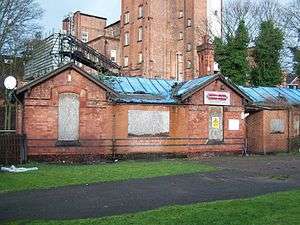
It was built in 1882 for the Midland Railway's Basford to Bennerley Junction branch, at a cost of £2,495 15s 7d, designed by Charles Trubshaw who went on to become a major railway architect.[1] It was designed according to the Arts and Crafts movement to resemble artisan cottages.[1] The rails used in the building of this branch line were taken up from Kimberley station to Bennerley Junction in 1916 and presented to the War Department for use in the battle for the Dardanelles during the First World War. The line from Basford to Kimberley remained in place.[2]
This line is now disused, the station is at one end of a railway cutting through which the branch line ran; this is now designated as a geological Site of Special Scientific Interest under the name of Kimberley Railway Cutting. This cutting is currently the private property of the brewers Greene King at its Kimberley end but a footpath follows its trackbed from Watnall as far as the M1 motorway.
It closed to passenger traffic in 1917 but remained open for goods until 1 January 1951. The station house was used for a while by Kimberley ex-Servicemen's Club and then Kimberley Social Club but after being derelict for many years was demolished in 2016-2017.[3]
| Preceding station | Disused railways | Following station | ||
|---|---|---|---|---|
| Watnall | Midland Railway | Ilkeston Town | ||
References
- 1 2 www.forgottenrelics.co.uk Bennerley & Bulwell Railway
- ↑ "Memory Lane, Kimberley Station". Eastwood and Kimberley Advertiser. 28 November 2008.
- ↑ Kingscott, G.,. Lost Railways of Nottinghamshire. Countryside Books.
Further reading
- Henshaw, Alfred (2000). The Great Northern Railway in the East Midlands. RCTS. ISBN 0-901115-88-6.
- Kingscott, Geoffrey (2004). Lost Railways of Nottinghamshire. Countryside Books. ISBN 1-85306-884-5.
- Lee, John.M. (2001). A Brief History of Kimberley (First ed.).
- Lee, John.M. (2002). A Brief History of Watnall (First ed.).