Scottville, Michigan
| Scottville, Michigan | |
|---|---|
| City | |
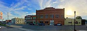 Panoramic image of Main Street facing the city hall | |
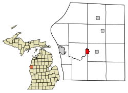 Location of Scottville, Michigan | |
| Coordinates: 43°57′15″N 86°16′54″W / 43.95417°N 86.28167°W | |
| Country | United States |
| State | Michigan |
| County | Mason |
| Area[1] | |
| • Total | 1.49 sq mi (3.86 km2) |
| • Land | 1.49 sq mi (3.86 km2) |
| • Water | 0 sq mi (0 km2) |
| Elevation | 692 ft (211 m) |
| Population (2010)[2] | |
| • Total | 1,214 |
| • Estimate (2016)[3] | 1,221 |
| • Density | 810/sq mi (310/km2) |
| Time zone | UTC-5 (Eastern (EST)) |
| • Summer (DST) | UTC-4 (EDT) |
| ZIP code | 49454 |
| Area code(s) | 231 |
| FIPS code | 26-72080[4] |
| GNIS feature ID | 1621550[5] |
Scottville is a city located in the north west of the U.S. state of Michigan in rural Mason County. The population was 1,214 at the 2010 census.
Scottville was named for Hiram Scott in a coin toss.[6]
On July 23, 2007 Governor Jennifer Granholm announced Scottville as the community chosen by the Michigan State Housing Development Authority (MSHDA) to take part in the Cool Cities Michigan Main Street program. Scottville will receive five years of intensive technical assistance through MSHDA, to help create opportunities for new development, economic growth and jobs. A similar award, the Blueprints for Downtowns award, were announced to be received by the communities of Caro, Clio and Ypsilanti.
Geography
According to the United States Census Bureau, the city has a total area of 1.49 square miles (3.86 km2), all land.[1] The city of Scottville itself is approximately 10 miles east of the city of Ludington and Lake Michigan, five miles west of the village of Custer and 10 miles south west of the village of Fountain.
Demographics
| Historical population | |||
|---|---|---|---|
| Census | Pop. | %± | |
| 1890 | 147 | — | |
| 1900 | 554 | 276.9% | |
| 1910 | 891 | 60.8% | |
| 1920 | 1,045 | 17.3% | |
| 1930 | 1,002 | −4.1% | |
| 1940 | 1,162 | 16.0% | |
| 1950 | 1,142 | −1.7% | |
| 1960 | 1,245 | 9.0% | |
| 1970 | 1,202 | −3.5% | |
| 1980 | 1,241 | 3.2% | |
| 1990 | 1,287 | 3.7% | |
| 2000 | 1,266 | −1.6% | |
| 2010 | 1,214 | −4.1% | |
| Est. 2016 | 1,221 | [3] | 0.6% |
| U.S. Decennial Census[7] | |||
2010 census
As of the census[2] of 2010, there were 1,214 people, 483 households, and 309 families residing in the city. The population density was 814.8 inhabitants per square mile (314.6/km2). There were 578 housing units at an average density of 387.9 per square mile (149.8/km2). The racial makeup of the city was 92.9% White, 0.9% African American, 0.9% Native American, 0.5% Asian, 2.0% from other races, and 2.8% from two or more races. Hispanic or Latino of any race were 5.3% of the population.
There were 483 households of which 34.8% had children under the age of 18 living with them, 38.9% were married couples living together, 19.7% had a female householder with no husband present, 5.4% had a male householder with no wife present, and 36.0% were non-families. 32.3% of all households were made up of individuals and 11.2% had someone living alone who was 65 years of age or older. The average household size was 2.51 and the average family size was 3.09.
The median age in the city was 35.1 years. 28.2% of residents were under the age of 18; 8.9% were between the ages of 18 and 24; 25% were from 25 to 44; 24.3% were from 45 to 64; and 13.8% were 65 years of age or older. The gender makeup of the city was 47.9% male and 52.1% female.
2000 census
As of the census[4] of 2000, there were 1,266 people, 525 households, and 345 families residing in the city. The population density was 866.5 per square mile (334.8/km²). There were 574 housing units at an average density of 392.9 per square mile (151.8/km²). The racial makeup of the city was 94.47% White, 0.63% African American, 0.87% Native American, 0.16% Asian, 1.26% from other races, and 2.61% from two or more races. Hispanic or Latino of any race were 4.82% of the population.
There were 525 households out of which 33.7% had children under the age of 18 living with them, 43.6% were married couples living together, 17.5% had a female householder with no husband present, and 34.1% were non-families. 31.0% of all households were made up of individuals and 13.7% had someone living alone who was 65 years of age or older. The average household size was 2.40 and the average family size was 2.97.
In the city, the population was spread out with 27.3% under the age of 18, 10.2% from 18 to 24, 25.2% from 25 to 44, 20.9% from 45 to 64, and 16.4% who were 65 years of age or older. The median age was 36 years. For every 100 females, there were 86.7 males. For every 100 females age 18 and over, there were 80.9 males.
The median income for a household in the city was $27,750, and the median income for a family was $36,875. Males had a median income of $26,583 versus $22,917 for females. The per capita income for the city was $15,703. About 15.5% of families and 18.4% of the population were below the poverty line, including 32.8% of those under age 18 and 1.9% of those age 65 or over.
Education
Scottville is home to West Shore Community College, a two-year college established in 1967.
Notable people
- Maynard James Keenan - musician
References
- 1 2 "US Gazetteer files 2010". United States Census Bureau. Archived from the original on 2012-01-24. Retrieved 2012-11-25.
- 1 2 "American FactFinder". United States Census Bureau. Retrieved 2012-11-25.
- 1 2 "Population and Housing Unit Estimates". Retrieved June 9, 2017.
- 1 2 "American FactFinder". United States Census Bureau. Retrieved 2008-01-31.
- ↑ "US Board on Geographic Names". United States Geological Survey. 2007-10-25. Retrieved 2008-01-31.
- ↑ "Focus on our history: How county was named". Ludington Daily News. October 3, 1987. p. 2. Retrieved 30 April 2015.
- ↑ "Census of Population and Housing". Census.gov. Retrieved June 4, 2015.
External links
- Official website
- The Official Ludington-Scottville Chamber of Commerce and Convention and Visitors Bureau
Municipalities and communities of Mason County, Michigan, United States | ||
|---|---|---|
| Cities | 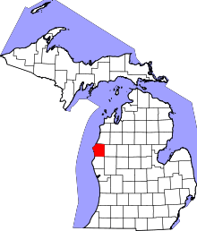 | |
| Villages | ||
| Charter township | ||
| General law townships | ||
| Indian reservation | ||
| Footnotes | ‡This populated place also has portions in an adjacent county or counties | |
Coordinates: 43°57′17″N 86°16′48″W / 43.95472°N 86.28000°W